I had been watching the 3-day forecasts everyday and Saturday was looking good. Driving to Avenal from Fresno the sky looked very hazy, without clouds, not your typical good looking soaring day. We assembled early and I intended to be in the air about 1 PM. I was hoping I could get to Tehachapi early so I could fly back to Avenal. The RUC forecast showed that at 2 PM conditions could be good in the valley. The two pilots who had flown on Friday said the forecasts had been too optimistic and where skeptical of this one. However when Steve Schery got off tow around 12:30 he called that he was climbing through 5300' msl.
I took off at 12:46 and took a 2000' tow then climbed to 4600' msl in my 1st thermal and by this time Steve was at 7000'. The day looked very promising. I headed out toward the southeast, a little to the right of the course line at 1:08 with an altitude of 5900'. I wanted to check how the air was between the mountains and the valley. I found a thermal and went up to 5800'. And while cruising my netto showed we where in a convergence. Things were looking good and the forecast seemed to be right on.
When I found my next thermal I was going to turn toward the east and head for Tehachapi but I continued sinking and found nothing until I was down to 2000' agl with Belridge off to the west. Here I climbed slowly back up to almost 3900' msl. This was beginning to feel like a day when you are in this area where you have to stretch your glide to get away from the green fields and make it to the barren dry areas near Elk Hills. Once you make it past the fields below you head for Elk Hills for about 10 miles going SE keeping your left wing looking at green fields and the right one looking at barren dry ground. Usually you will find a shear line, and if not, at least a thermal along this line. About 3 miles out I again was down to 2000' agl until I found a thermal and slowly climbed back to about 4500' msl.
The mountains 30 miles off to the S and E looked terrible and I decided to continue going SE to Buena Vista, a man-made lake about 3.5 miles long with a combination of bare hard ground to N and cultivated fields to the S and E. Again, a shear is usually lurking here somewhere even on the weakest of days. I arrived at about 2300' agl and the shear got us back to 4000' msl.
We now headed E and glided about 6 miles to I-5 Freeway getting down 2500' agl. None of the fields gave any sign of lift and so I turned SE and flew down the freeway slowly losing altitude for about 4 miles until I finally caught a thermal where we crawled back to 2300' agl. While climbing I had noticed some small dust devils close together about 2 miles to the SW and went for them. They got me back up to 2700' agl.
I then headed W again toward the 99 Freeway 4 miles away and climbed in a thermal to 3200 agl along the way. At the 99 we only found a little bump so we continued on. At this time the air felt less buoyant. Looking at the NAM forecast after the flight it shows here is where I would be going into an area of reduced lift. (I will have more respect in the future for NAM) I glided down going to the ENE 10 miles toward the town of Arvin and landed there at the J and J Crop Duster strip at 3:27.
I looked at Bear Mountain looming down on me to the east with Tehachapi hidden behind it. I was 20 miles short, and I will have to try again. Over the years it has always been a great adventure trying to reach this goal. It is indeed possible. The 1st time was in my Blanik when I thought anything was possible, then the Nugget and the ASW20 when I knew better.
The crew at J and J were very friendly and hospitable, and I could not had made this attempt without the assistance of my crew, Don Van Wyk, who gave up a day of flying at Avenal where they were topping out at 8300' msl.
Mario
View Flight on OLC
Alby flight No. 8 and Pin No. 4 - Jonathan Hughes, 3/22/09
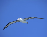
 Alby enjoyed his stay at Hollister but he was getting restless and wanted to get going on his journey to the east. Alby wanted to get to Avenal and I offered to give him a ride in my glider. He has enjoyed flying around in a Discus, ASW-27, and DG
 -800 so he was looking forward to seeing what it is like to fly in an Jantar. He wanted to go last weekend but the high cirrus made that impossible. This Sunday was looking promising and with the rain coming in on Saturday evening it was looking like a good post-frontal day.
I got a late start on Sunday and didn't get to Hollister until a little after 11:00AM just in time to see BG take off. I quickly collected Alby from the HGC office and tucked him snuggly into his traveling case. I have been working on various little projects on my glider for the past several weeks so it took me a little time to make sure everything was back together and ready to go before taking off (more about that later). In the meantime, a rain shower had moved in from the north which delayed us even more.
I finally took off about 1:30PM and took a 3,700ft AGL tow to Kelly's Ranch airstrip 4.5nm northeast of Hollister which was the closest thermal. The rules for Alby state that you should release below 3,000ft and to the west of the airport when Alby is flying east. I cla
 rified with the Albymasters that the conditions in Hollister would probably require special dispensation and received a waiver from the tow height and release rules for my flight. Alby said he felt our flight met the spirit of the rule as we released as low and close to Hollister as possible on the day we flew.
Conditions were soft at first and the wind was blowing from 305 at 21kts. I was able to climb up to about 5,000ft before heading out towards Los Banos. I was finding lots of sink in some areas and not being very high I was a little worried about how easy this flight was going to be. Alby said not to worry and found a few thermals when we got low. Every time I found myself in a position where I either needed to climb or head towards my landout option Alby found a thermal.
It was about at this time that I noticed that the arrival altitude for my landout option on my PDA was changing but the distance didn't seem to change. I also noted that the direction of flight seemed to be in the wrong direction. A little bit of troubleshooting revealed that the logger was communicating with the PDA but the logger thought we hadn't moved from just south of the San Luis Reservoir. Alby said not to worry, we could complete the flight using ded reckoning and since I always have a sectional with me we didn't have any trouble figuring out where we were.
Our route of flight was from Kelly's Ranch to the north east towards Los Banos and then south towards I5. Conditions got stronger as we got closer to Mercy Hot Springs and by the time we made it to Harris Ranch I knew we had Avenal in glide. The problem was a line of rain showers that stretched from San Benito peak past Coalinga to the foothills east of Avenal. I was fairly sure we could get through but I couldn't see the runway and wasn't sure what the condition of the surface would be after all the rain.
As we appro
 ached from the east it became obvious that the rain was more to the south and the airport was in the clear. I flew a little past Avenal to show Alby the direction he would want to go later before landing at Avenal about 3:35PM. Ironically, with all the wind at altitude the winds at Avenal were light when I landed but picked up later in the day by the time I towed out.
No one appeared to be around when I landed and I was a little concerned about leaving Alby alone but Loyal Savaria showed up a little while later and gladly accepted Alby on behalf of the Avenal club. A little later, a member of the Avenal city council showed up and gave Alby
 an official welcome.
Although Alby and I only got to fly together for 2.1 hours we had a good time and I'm looking forward to following his journey as he makes his way across the country. I don't have a logger trace for the flight but the route was right over I5 most of the way. I got as high as 7,000ft and as low as 3,600. Winds were strong from the north but there was no wave found.
Jonathan "UV"
(and Alby)
See Flight on youtube http://www.youtube.com/watch?v=dkYWrTao3T4
Alby flight No. 7 and Pin No. 3 - Buzz Graves, 3/5/09
As I mentioned in my previous attempt, timing is everything in the early season in the Bay Area with the best soaring happening on the backside of a low center that brings rain to our area. I had to arrang e for time off from work 3 days in advance, I made the call and placed my bet. It had been raining off and on for nearly a week when the first break was showing on the satellite images. The day started off looking quite good as cu’s were forming of the mountains very early, say around 10 am. There was plenty of blue sky from my view in the South Bay as I left my home with my glider in tow. My drive is around 1.5 hours and I was studying the sky intensely all the way to the airport, that is until I drove over Altamont Pass again and found the central valley socked in again, nearly the same start point as my previous attempt a few weeks earlier. Rather than panic, it was early enough to stop for breakfast and get a window seat to watch the sky, while wishing and hoping filled my thoughts. But while getting myself ready to drive back home I noticed it was improving. In another direction from my window I was seeing blue sky dotted by small cu’s, albeit with very low cloud bases, maybe 1500’ AGL.
As I rigged things kept looking better with cloud bases rising, it was looking like a certain thing that I would be sharing the skies and experience with Alby. Forecast was for better conditions to the south and I knew that the early going was going to be a ground skimming experience with cloud bases around 2500 AGL. Normally I would have worked towards the mountains where the cloud bases are much higher with better lift, but by the time I launched it had over developed and the clouds were sitting on top of the peaks with no room for Alby, me and my glider. So off I went south down I-5 following a string of airports that I kept clicking off every 10-15 miles. It was a day to fly very conservatively, one wrong step and we were going to be landing out. For the first 30 miles we rarely got over 2500 AGL.
In order to make it to Hollister I needed to climb over the mountains to get to Hollister from the central valley. On the first attempt I didn’t connect and retreated, on the second attempt I connected with a climb to over 4k with good lift being marked by clouds towards Hollist er. The only challenge at that point was to dodge the columns of rain and hail that where falling from some very dark cumulus clouds that were very serious looking. Alby and I got a little wet on the way and landed in bright sunshine at Hollister. We were greeted by the local glider pilots and congratulated on our flight, a little surprised that I appeared out of that darkened sky to the east. I made the introduction and now Alby is their guest until he gets help from those at Hollister. I believe his next destination is Avenal in the central valley of California.
 e for time off from work 3 days in advance, I made the call and placed my bet. It had been raining off and on for nearly a week when the first break was showing on the satellite images. The day started off looking quite good as cu’s were forming of the mountains very early, say around 10 am. There was plenty of blue sky from my view in the South Bay as I left my home with my glider in tow. My drive is around 1.5 hours and I was studying the sky intensely all the way to the airport, that is until I drove over Altamont Pass again and found the central valley socked in again, nearly the same start point as my previous attempt a few weeks earlier. Rather than panic, it was early enough to stop for breakfast and get a window seat to watch the sky, while wishing and hoping filled my thoughts. But while getting myself ready to drive back home I noticed it was improving. In another direction from my window I was seeing blue sky dotted by small cu’s, albeit with very low cloud bases, maybe 1500’ AGL.
As I rigged things kept looking better with cloud bases rising, it was looking like a certain thing that I would be sharing the skies and experience with Alby. Forecast was for better conditions to the south and I knew that the early going was going to be a ground skimming experience with cloud bases around 2500 AGL. Normally I would have worked towards the mountains where the cloud bases are much higher with better lift, but by the time I launched it had over developed and the clouds were sitting on top of the peaks with no room for Alby, me and my glider. So off I went south down I-5 following a string of airports that I kept clicking off every 10-15 miles. It was a day to fly very conservatively, one wrong step and we were going to be landing out. For the first 30 miles we rarely got over 2500 AGL.
In order to make it to Hollister I needed to climb over the mountains to get to Hollister from the central valley. On the first attempt I didn’t connect and retreated, on the second attempt I connected with a climb to over 4k with good lift being marked by clouds towards Hollist
 er. The only challenge at that point was to dodge the columns of rain and hail that where falling from some very dark cumulus clouds that were very serious looking. Alby and I got a little wet on the way and landed in bright sunshine at Hollister. We were greeted by the local glider pilots and congratulated on our flight, a little surprised that I appeared out of that darkened sky to the east. I made the introduction and now Alby is their guest until he gets help from those at Hollister. I believe his next destination is Avenal in the central valley of California.
 I said my good byes and headed back to Byron. A great day and a great experience for all.
The flight of the Albatross across our Country caught the attention and the fantasy of a newsmaker, Adam Breen, who published a well written and inspired article in Hollister's "The Pinnacle" newspaper: http://www.pinnaclenews.com/news/contentview.asp?c=255106
Alby flight No. 6 - Buzz Graves, 2/18/09
This time of the year can be very tricky for flying cross country in the Bay Area, and timing is everything. If you catch the backside of a low pressure disturbance when the rain stops falling, condition can be very good if you don’t mind low cloud bases. In looking at the weather on this day my window was going to be numbered in hours and my timing had to right on within hours. The exiting low was leaving and the next one was right on its tail and had the normal high cirrus coming in ahead of the front. Work didn’t allow much flexibility and so when this day came I was ready to try.
The drive to the field some 60 miles away from my home in Los Gatos was looking optimistic with cu’s forming over the range of mountain that normally offer good lift in the direction of Hollister, Alby’s next destination on his way across the country. However, about 10 miles from Byron airport I crossed over Altamont Pass dropping me in the central valley and it was completely socked in with fog, and it was around 10 am. Optimism still was there as I knew the fog would likely burn off as it normally does, we just don’t know when. The clock was ticking and the upper cirrus was coming my way.
I rigged and waited while the sky was clearing and small cu’s were forming. Cloud base was not much above 2.5k agl near the airport and looked better to the south in the direction of Hollister. So off I went in a dead glide in the direction of the clouds and got a low save over Tracy. Still seeing better clouds to the south I pressed on. Alby was getting a close-up view of the traffic moving down I-5. Winds were showing some southeasterly direction and that had me ridge soaring the low hills just west of I-5.
Several saves with hawks marking the lift along the way, this showed to Alby other flyers who have learned to harness the energy in the atmosphere. I was showing Alby all my skills accumulated over the 28 years of flying gliders in southern Arizona and ridge flying in Hawaii for 12 years. To the south I could see that the clouds were much better and pressed on. My progress was going to be too slow as I watched the cirrus move in from the west and shut down the source of all our energy in the atmosphere, the sun. Those clouds with flat bottoms and white tops turned grey and soft and I knew the attempt was over and headed back to return Alby to Byron for another attempt on another day.
P.S. As luck would have it the next three days the weather gods came together and each looked good enough for an attempt. It is the reality’s of life that many things control what we do with our time, and my time was needed else where. Alby would have to wait for another day for me to try again.
View Flight on OLC
Subscribe to:
Posts (Atom)
Tracking the flights with SPOT

Where in the world is Alby?
Scroll below to follow Alby flying in real time. For more detailed information on the flight go to our Spot satellite tracking page.
Position updates are broadcast in real time every 10 minutes, although occasionally there may be delays. If Alby is not flying at this time, the trace shows Alby's most recent flight. Traces are left posted for the duration of one week only. However, the flight can be seen on OLC.


.jpg)
.jpg)
.jpg)
.jpg)
.jpg)
.jpg)

.jpg)
.jpg)
.jpg)
.jpg)
.jpg)
.JPG)
.jpg)
.jpg)

.jpg)
.JPG)


