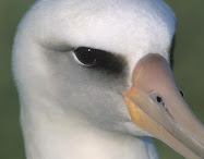
Alby's Progress

Map Legend

___ Successful Legs
___ Attempts
___ Proposed legs

Click, hold and move the mouse to move the map.
Point hand's finger, click on markers to read airport information.
Point hand's finger, click on path legs to read flight information.
Click on Sat (top right) to see aerial picture, enlarge to see airport.
Click on "View Larger Map" above to see full screen .


latest news

12/18/09 - MORE AND MORE WINTER PLANNING - E-mail from Charles Cook, North Carolina SSA Governor. These guys are very interested to fly Alby to Kitty Hawk:

We have plans to move Alby from Piedmont Soaring to Harnett Co. from there either to Ball Field or Farmville. The hope is then to go either to Tidewater or to Kitty Hawk. Until the time is closer can't say more. I would love to see Kitty Hawk involved. I will be involved in the flight from PSS to Harnett. We may try for a group flight wih several gliders. Charles Cook

12/11/09 - MORE WINTER PLANNING - E-mail to Wayne:

Hi Wayne

I need a person that can follow the contacts with the media during Alby's voyage. Do you think you can do it? You have shown interest.

I think that most of the work will be done by the various clubs along the path, who know the local media better. But they may need input on what to say and do.

Also, there may be the opportunity to contact media at a higher level, state or national, and it would be better if this was handled by a coordinator. Do you think you might have the time and drive to do it? It all depends how much motivation you have, because the activity involved is absolutely fascinating for an interested person. Sergio

11/26/09 - WINTER PLANNING - Weather forces to activities like writing in place of flying (sigh) but this will facilitate our next soaring season. So this is the planning for Alby's Voyage:
1) Take Alby to the Atlantic fulfilling the tale written in the Story in the website. This part of the voyage was organized so as to guide Alby through the Country avoiding dead ends and grant a situation of "mission accomplished".
2) Have Alby come back slowly to the Pacific, touching all the gliding sites that wish to host him. In this part of the voyage we aim to seek the attention of the local media so as to publicize our sport to the public at large.
3) Free the spirit of Alby to his native Pacific Ocean with a symbolic flight over the waters. The sculpture will be then conserved in an appropriate location - Ray Gimmey suggested the National Soaring Museum in Elmira.

11/22/09 - SOME MORE WINTER ACTIVITY - E-mail from Sergio to Wayne: That's great Wayne! Another example of action taken before even asking for it. Glider pilots are a formidable bunch!

I will put your name in the Map as the Albypilot for your leg. And I will tell Dean Forney - who will probably be the pilot from Midlothian to Shreveport - to put on his mascara before landing there in front of the TV. Sergio

E-mail from Wayne Crank Jr. Hello Sergio: I will be the pilot from Shreveport - Pisgah. As for the media, that is already in the works. I have several friends in the television, radio and newspaper industries in this area. When I mention the Alby Flight to them, their eyes grow wide open, and always ask, IS THAT POSSIBLE? I always reply, OH YES. They all want me to notify them when Alby comes through here. Thanks. R. Wayne Crank, Jr.,

E-mail from Sergio to Wayne Crank Jr.: Hi Wayne. As you know Alby is in Midlothian now and he will stay there until Spring. I would like to place the name of an Albypilot for the leg Shreveport-Pisgah. So if you have one - or more - let me know and I will place it in the Map in Alby's website.

I recognize that your leg is not an easy one because of the length and the challenging soaring conditions in your area, especially so at the beginning of the season. But remember that the trip does not need to be done in one single flight and it can be done in more than one flight if difficulties arise, because one can take off again from the last landing point. These situations have been foreseen and have been incorporated in the Rules as shown in the Alby website.

Also, we are interested to make Alby known to the general public. Could you guys make the story of Alby known to local newspaper, TV etc? This kind of stories are well received by the public and the press is always looking for this kind of events. It is not known when Alby will be arriving there so we will have to wait for that day but some contacts with the press may be taken in advance, now that there is time. When Alby will be there the time will fly very rapidly unless a minimum degree of preparation has already been made. Thank you and a happy Thanksgiving to you! Sergio

11/14/09 - MORE WINTER ACTIVITY - Dear Alby followers: The voyage to Kitty Hawk is almost completely arranged and I do not see difficulties in that direction. From there, Alby will slowly come back to the Pacific Ocean where his voyage started. I foresee that Alby will take a route to the north first, to visit the numerous glider sites there. However the trip back will be less focused on reaching a destination, and more on telling his story and reaching the souls of the people, not only inside the soaring community but also beyond the soaring community. We want the general public be reached and made interested to the story of Alby and to our sport.

Alby can be made known through newspapers, magazines, television, YouTube, and other places. I think this would be an absolutely interesting activity, and we need to find a person that is able to organize and follow this activity. So I am asking for your ideas about where to find a person that would be amenable to get involved in this task. Taking over the publicity for Alby's Journey and making it a nationally known event could really bolster the publicist's status, and also get information about Alby and the sport of soaring into people's homes. The right person would be an exceptionally good addition to our team.

Researching, contacting, writing, and following up on it all is a pretty big job. A thought is to find a college student majoring in journalism and/or advertising who needs to have a portfolio of actual work accomplished to show prospective employers. How to find such a person? I am sure among 300 million people there are at least 300 that could organize this job egregiously and have fun and satisfaction. Of course the challenge is to let them know. So I am beginning with you guys. Would somebody of you be willing to try? Would you know a person who could do it? Would you know a person that may know a person that could do it?

Just reach out a few feet, ask and relay here. Suggestions, ideas are welcome. Thank you all! Sergio

11/1/09 - WINTER ACTIVITY - This the season of limited flying activity for a glider pilot, of savoring past accomplisments and preparing for new ones. So in place of reporting about flights, we will report on what's going on in the organization of Alby's future path and adventures. More plans and more e-mails will be shown in this column.

Sergio to Robert Hey, October 31:
Hi Bob (Hey). So here is the answer from Bob (Herndon). The two of you can agree which week you want to try first.

Now a word about the reservations: The Rules are applied literally if there is no different agreement between you two (or more) guys: so one pilot has one week to do the flight, after which the other pilot may try. But the Rules are very flexible depending on you: If Bob (Herndon) finds that he cannot fly in the week he has reserved, the other Bob (Hey) can fly instead. If Bob (Herndon) finds that he cannot fly for three days in the week he has reserved, the other Bob (Hey) can fly for those three days instead. Etcetera. Provided you two (or more) agree, any arrangement is good.

It is always recommendable to tell the Albymaster, who will update the calendar, so everything is clear for everybody. Remember that this includes the people at home following the adventures of Alby. So when you answer an e-mail, push the "Reply All" button and the information will go to everybody interested including the Albymaster.

Thank you Bob (Herndon) for your hospitable move to Bob (Hey)! Sergio

E-mail from Robert Herndon, MS, October 31:
I can arrange a tow at Pisgah if Bob Hey wants to take the leg when Alby gets here. If he can't do it, I may give it a try. Bob Herndon

Sergio to Eric Hey, October 31:
OK now the first thing you want to do is to read the Rules in the website at http://www.blogger.com/. We have established these rules just to try and accommodate everybody. The Rules have been purposely kept short and simple to adequate to this age of fast an essential information.

Yes, you may want to contact the people at the glider site of your choice to make arrangements for a tow, to tell them that you want to fly that particular leg etc., and in general as a courtesy call to introduce yourselves to your fellow glider pilots.

According to the Rules, one pilot or one team reserves one week and has that week to try and make the flight. If they do not make it, next week somebody else can try etc. In the Calendar (at the bottom of the website) is shown who is the pilot or team that has that particular week reserved.

You can reserve any week right now, but only one week in a particular gliding site. If you cannot make the flight in that week, wait when it is your turn. As a courtesy to that glider site, please give them the first choice. After they do it, or if they renounce to do it, go ahead and ask to reserve your desired week. You can do the reservation at any time, either now or next spring. In Pisgah, the contact is Robert Herndon.

Always cc: to albymaster@pacificsoaring.org so we know what is going on. Go for it! Sergio

E-mail from Eric Hey, AL, October 31:
Sergio, we would like to offer to fly two legs of the Alby Voyage flight. My father, Bob Hey, is game to handle the Harrell Field (Piscah, MS) to Starkville, MS leg. I will fly the Starkville, MS to Sylacauga, AL leg. Do we need to contact the two respective glider clubs to make arrangements for tows? Eric Hey

Sergio to Robert Hey, October 27:
Hi Robert. Ok we'll try our best to let you fly a leg. Now the leg from Sylacauga to Huntsville has been claimed by your friend Bill Elliott and he will be the first to try. However, you can try to fly other legs. For example, the leg from Mississippi State University (Starkville) to Sylacauga. That is not that hard to do. Or, the leg form Pisgah to Starkville. That is a little more "harder" but remember that it can be done in more than one flight, landing somewhere along the track and then taking off again, having one week to complete the task. Read the rules at http://albysvoyage.blogspot.com/.

Anybody can ask to fly with Alby. You can also fly the leg from Sylacauga to Huntsville if your friend Bill does not make it in one week. When the time comes, follow the adventures of Alby in the website, and be ready to ask to fly a leg. Got it? There is fun for everybody if a body is just ready for it! Sergio

E-mail from Bob Hey, AL, October 27:
Sergio, my name is Bob Hey. I have an interest in being a player in the "Alby Flight". My son Eric owns a LS4a and I have a LP-15 Nugget - based in Sylacauga, Alabama. We are active members with the Sylacauga Soaring Society.
Each of us is willing to help bring "Alby" on it's way to Kitty Hawk. If there is any leg in Alabama that we can help with please let us know. Perhaps we can handle a leg or two on this journey. Thanks in advance, Bob Hey.

10/17/09 - SOME MORE POOR WEATHER - Well at this time of the year, it is more reasonable to have poor weather. However, still some cold front may produce usable conditions.

10/08/09 - TEXAS WEATHER: THUNDERSTORMY! - E-mail from Dean Forney:

Sergio, I’m sure you and everyone else is wondering what’s going on with Alby! As you have seen, the weather has been terrible for soaring attempts for the past month or more. As I write this, the forecast in this part of the world is for possible tornados and severe thunderstorms with flash floods likely for the next 48 hours. We continue to watch for the possibility of another attempt to move Alby on to Louisiana, but it looks bleak for the near future. Presently Alby is safe and warm, sitting in my study here in Gainesville, TX. Will keep you posted of any developments.

I was crewing for Steve on Sept 7, and Elizabeth & Glenn Maynard, as well as Steve were crewing for me on Sept 27. Bless their hearts, they sat on the ground all day at TSA and cheered my futile attempt on! Thanks to all of them for the effort.

E-mail from a fan: Just a quick note to let all of the Albypilots and crew know that your fan club is watching! I'm in northern cal not far from the start of Alby's voyage and am the sister of pilot Dean Forney who just completed the most recent leg to Decatur, TX. I am and will be one of the many fans following the trip and want to send kudos to all of the participants, especially for the Tales of the Flights. May the soaring gods shine upon you all! Diana Ingram

The flight of the Albatross across our Country caught the attention and the fantasy of a newsmaker, Adam Breen, who published a well written and inspired article in Hollister's "The Pinnacle" newspaper: http://www.pinnaclenews.com/news/contentview.asp?c=255106


Tales of the flights

The Dallas plan

Note below is from Terry Stroud, volunteer and perhaps pioneer on the Decatur, Texas-to-Gilliam, Louisiana leg. We trust his skills and wish him well. Ed.

Alby watchers.....

Alby has landed in Texas, south of Dallas. After visiting with a new ground-bound friend (see picture) the talk turned again to flying eastward. Alby then learned that the next stage is something of an adventure, a journey into the unknown.

It turns out that while humans know all about (and travel all over) the land underneath the leg ahead, very little is known about the air itself. Just 20 miles east of Alby's location marks a point that human just don't normally go beyond. Unlike Alby, the humans use maps of the sky and "turnpoints" to navigate from place to place on the currents. "Turnpoints" are a kind of collective wisdom of the humans who have glided over these markers. "How is it around Kaufman?" they ask. "Not bad" says another. "Just stay away from the lake to the south." Just east of Alby, turnpoints do not exist. No one goes there. It is not impossible for motorless flight, it just gets so much harder.

The first difficulty, Alby learns, is water. Water and waves are friends Alby knows well, but on the big expanse of land, it seems that water can be an enemy to flying. Water from rivers and recent rainshowers have soaked the ground that lies ahead. The wet ground greedily soaks up the warmth of the sun and lets the air have very little of it. Also ahead is an obstacle not created by the earth, the water, or the air. Alby has experienced this strange obstacle before, this odd set of rules that govern the sky called "airspace." This time it lies right where the distance would be shortest, right where, indeed, the water can be avoided. The airspace can be traveled around but the price is longer distance and less choice of path.

There is no danger ahead, just study, trial, and perhaps error. Alby thus settles in with his next airborne guide to study the land, invent new "turnpoints", and explore the air that the human flyers know so little about.

A little about Alby's next guide....

Terry has close to 1000 hours in the air, and about 24,000 miles of cross country experience. He has flown a 2-33, a 2-32, a 1-26, a Grob 103, a Puchaz, an ASK-21, a PW-5, a Stemme s10, a Glasflugel 303, a Duo-Discus, an ASW-27, a 304S Shark, and currently owns and flies a Ventus Ca.

Alby flight No. 22 and pin No. 14- Elizabeth Maynard 7/25/09

Alby Flight No. 14 – Decatur to TSA

Two weeks before the Alby flight…


I must have had sunstroke because after three days of playing with airplanes and gliders in record high temperatures of 108F I announce that I will fly Alby from Decatur to TSA. I, who only got her gliding licence last September and who had never flown more than 16 miles from her takeoff airport, now thinks that flying 65 miles for a first cross country, over twice that required for the Silver distance, makes perfectly good sense. When I get home, I email Dean Forney, one of the most knowledgeable glider pilots I know, and inform him of my decision. “Go for it”, he writes back. I email Francis, one of the officers of our club, and ask her to let Sergio know. She does, but politely asks me “isn’t it rather like jumping into the deep end after just learning to swim?” That strengthens my determination to do the trip. I always rise to a challenge. So it is all set; everyone is informed. But by Thursday, when the sunstroke is fading and the reality of the task ahead is sinking in, I realise I must have been very ill indeed.

You may wonder what gave me the audacity to believe I am capable of such a distance with such little experience. Since buying a beautiful Russia (AC-4C) earlier this year I have wanted to fly cross country. I have been practicing all the exercises suggested by the experts. I have practiced flying small cross country triangles around Decatur. I have made many flights of over 2 hours and if other pilots can stay up, I usually can too. Through writing articles for my club newsletter I have spent much time considering landing out and cross country planning. I was beginning to feel ready for the club standard 35 mile jaunt up to Gainesville. Then along comes Alby.

One week before the Alby flight…


As Alby gets closer to Decatur, on the wings of Dean’s Libelle, I can see more clearly what I have volunteered for and I start to think I have made a really stupid decision. I email Sergio so no hopes will be built up. Two things I don’t tell him. Firstly, I will actually have to fly 85 miles around DFW’s class B airspace. Secondly, my small trip to an airport 16 miles away was actually at Moriarty on a day when other pilots were flying 500 km courses. His reply informs me many people will be following my flight. Secretly I pray for an internet meltdown.

One day before the Alby flight…

I had originally intended to fly to TSA in very loose formation with my good friend and gliding guru, Steve Altman. But as I watch the weather forecasts, it looks like I will be able to make the flight the weekend after Alby arrives at Decatur. I know Steve will be working then, so hope I can delay the flight until the following weekend. I meet up with Dean on Friday afternoon. He gives me a serious look over his cafĂ© au lait. “Well, Liz”, he says. “It looks like tomorrow will be the best gliding day of the year”. I know I can’t pass such a day up and will have to make the flight without Steve. It will be just me and Alby.

The Alby Flight...

The most important things I take with me into the cockpit are three pieces of advice:
1. If you don’t want to deal with an emergency, don’t create one – Jim Vickery (He actually tells a short story, but this is the moral of the tale.)
2. Get high, stay high – Dean Forney
3. Only worry about the waypoint behind you and the waypoint ahead of you – Steve Altman


Launch No. 1:

I had arranged with the tow pilot for a 12 noon tow and things are going pretty much on time. I plan on sampling the conditions before I leave. I am not going if the conditions are not as good as Dean has promised. After releasing at 2500 ft AGL into a clear blue sky I find a marginal thermal that keeps me from descending, but doesn’t offer me any decent lift. But feeling it might grow into something bigger, I decide to work it for a while. Unfortunately it is in the power aircraft traffic pattern and, for the first time ever since I have been flying at this normally very quiet airport, three training aircraft simultaneously arrive to practice touch and goes. Floating 500 ft over them makes me nervous and I move off hoping to find another thermal. Nothing. Neither lift nor sink and I gracefully float back to earth.

Launch No. 2:

Despite the still blue skies, and despite two other pilots launching and finding nothing I relight immediately. I release into a strong thermal. It takes me up to 3200 ft AGL and then breaks up. I lose it, try to find it again, give up, try to find another thermal, hit sink, head back to Decatur, hit strong lift on final, deploy full spoilers and still need a slip to get down. I land and look up. Cumulus clouds are beginning to develop. High ones, with dark concave bottoms and well defined development. I run my glider backwards up the runway to get relaunched.

Launch No. 3:

A little before 3 PM I release at 2400 ft AGL, this time into a whopping thermal that drives me up to 7000ft AGL. I know this is it. Just to be sure before leaving Decatur’s airspace, I fly towards a neighbouring cloud and again, find 4-6 kt lift. No question, this is it. I radio to my ground crew, a.k.a. husband, to switch to 123.5. This is the signal for him to start driving south.
My progress is slow going. Firstly the winds are from the southwest, with a 10 kt headwind component. Given that the best L/D of my Russia occurs at 50 kts, my ground speed is unimpressive to say the least. Secondly, I am following Dean’s advice and staying high. Cloud topped thermals are abundant and I am able to dolphin from one to the other, straying only slightly off course. Occasionally I stop to thermal in the strongest for the pure joy of rocketing upwards at 6-10 kts. (You have to understand, here, 2 kt thermals are normal; 4 kt thermals are considered a treat.) In this fashion I am able to stay above 6000 ft AGL…until I get to Parker County Airport, a third of the way on my route.

Then everything seems to stop – the road I have been following, landmarks, the abundance of clouds. A few scraggy, poorly developed cumuli break up the blue, but these are miles apart (25 miles at my guess), far too infrequent for the glide performance of my Russia. I stop in a thermal just south of Parker County and try to squeeze every last inch out of it. Given that the southerly wind is blowing me back up my track, I know this isn’t a great idea, but I need time to think. Was I about to create an emergency? At that point my crew asks for my position. After I answer, a second male voice comes over the radio.

“Are you the pilot bringing Alby to TSA?”
“Yes,” I reply. “If I make it.”
“I’m the next Alby pilot,” he says. “And you’ll be fine. You’ve got a few hours left.”

For the first time I look at my watch. 4:30 PM. I have paid no attention to the time until now and it is later than I would have liked. I can feel panic seeping into my bloodstream. There’s no way I can do this, I think. It’s too late. There’s no lift out there. I’m doomed. And the internet meltdown hadn’t happened. I start irrationally veering off to the west towards a deceptively good looking cloud. Panic is beginning to affect my thinking. I kick myself as best one can in a small cockpit. I read Steve’s words in my mind – one waypoint at a time. I look south. I can see the bend in the east-west road that curves around Bourland airport, 11 miles away. I am at 6000 ft AGL. I have two choices. I can land now and end this anguish. Or I can just head out to Bourland. I have enough altitude to make it there. I will either find lift or not and once I get to Bourland I can re-evaluate my position. So like a diver jumping into the water, I hold my breath and turn south.

There is little I can do other than fly along like a blind man with a cane and hope I will bump into another thermal. I can’t reach any of the clouds and the ground is uniformly brown and barren, offering few clues about thermal generation. After only 5 miles a small bubble allows me a few turns and I gain a 1000 ft, and so pass by Bourland at 6000 ft AGL. Things are still not too bad. My next waypoint is Embry, almost 20 miles away, although there are a couple of landout airfields enroute if I need them. I fly in smooth air for 10 miles and then finally stumble into a moderate thermal that bears me back up to 5500 ft AGL. I continue on, my vario alternating between crooning and lazy chirps. Three miles later I feel something good. I turn but sink like a rock. I have just been tricked out of 500 ft. I am down to 4000 ft AGL. With one of my landout airfields almost under me I continue southeast, expecting that I will soon have to turn back and land there. I give it a thorough checkout as I fly by. This is where it will all end. The slow descent is like a slow death. Part of me wants to land and get the inevitable over with.

Some gentle lift tickles my wings. My vario chirps with a little more enthusiasm. I slow to milk this for all I can get. Then suddenly…Bam! A giant bubble of air slams against the underside of my glider. My vario screams like a hyperactive canary. I throw the glider into a 50o bank, drop the nose a couple of degrees on the horizon and kick the rudder to quickly get my nose around. There is no way in hell I am losing this one. And bingo, I hit the bullseye and ride 6 kt lift like an express elevator through 4000 ft AGL…5000 ft…6000 t then…

Ding.

My GPS gives me an airspace alert. The southwest wind has blown me uncomfortably close to the Class B. I have no choice but to leave and pick up a heading that will keep me close to, but out of the airspace. And so I learn a new definition of pain – leaving the only thermal this side of DFW while it’s still bubbling like the brew in a witch’s cauldron.

With enough altitude to continue on, I start looking ahead for Luscombe, my next landout field. I see it and it looks like a comfortable glide. I check the distance on my GPS and I notice that TSA is now within gliding range. I pause. I am surprised. I had been so sure I would be landing out I had forgotten about TSA. But now it slowly dawns on me I might actually make it and a small flame of hope ignites in the back of my mind.

I turn east. If I hit sink, I can still make Luscombe, but I find neither lift nor sink. For 15 miles, nothing. Absolutely nothing. Luscombe becomes an unreachable dot on the horizon behind me. My GPS tells me TSA is only 4 miles away. In this featureless terrain, I still don’t see it. I am at 2200 ft AGL and I can’t see the place I’m hoping to land at. It is disconcerting. But the numbers tell me I will make it, and I have no choice but to believe them. Still, I am picking out suitable fields as I go. I see a long whitish building and I remember a long hanger on the airport diagram on their website. That must be it. I head straight for it.

At a little after 6 PM I cross the centreline of the runway at 1600 ft AGL. I have little altitude to spare. I enter the traffic pattern and land. As I step out of the cockpit it occurs to me that if my life was a movie, at this point the orchestra would start up and I would give some teary speech about this being the best moment of my life. But, after hours of keeping my emotions under a tight rein so reason and common sense could prevail, I can only feel hunger and the need for the bathroom. We tow the Russia in. I wake up Alby who’s fallen asleep watching the barograph. After Terry Stroud lands, I pass Alby into his care for the next long and difficult leg of Alby’s voyage.


The day after the Alby flight…

My excellent crew and I sleep late, then treat ourselves to a leisurely breakfast. I am still exhausted, but Glenn needs to get his gliding fix so we head out to the airport, arriving later than usual. We are assembling the Russia when Dean drives up.
“Hey Liz,” he calls. “Everyone is waiting for you in the hanger.”
As I walk in I am greeted by congratulations and well dones from my fellow club members. Jim presents me with a bunch of flowers. Dean shakes my hand.
“Well done, number 14,” he says.
“Thank you, number 13,” I reply. I can’t help smiling. To hell with reason and common sense. This feels good. This feels really good.

Elizabeth Maynard

Alby flights No. 20 and 21 and pin No. 13- Dean Forney 7/19/09 and 7/21/09

Alby's Log, Leg #13: Littlefield to Decatur (leg one)

I met Steve and Reba Altman at the North Texas Soaring hanger in Decatur after I got off work Saturday. After looking at a couple of driving routes to Littlefield, Steve suggested we drive the one that was closest to the planned flight route so that we could study the terrain and check out possible land-out sites. We hitched up the Libelle trailer to Steve's truck and headed west at around 3 PM. We saw some vast areas of beautiful and colorful country. We saw some vast areas of ugly land-out possibilities. When we arrived in Littlefield, we drove out west of town to find the airport then checked in to the newest and nicest Best Western Motel in town. The lady at the desk gave us directions to a great authentic Mexican restaurant where we enjoyed a great meal. The forecast for Saturday was for a 40% chance of thunderstorms. As we left the restaurant we were treated to a spectacular display of lightning and could see the glow created by a large field fire caused by lightning strikes. I think all of the 40% thunderstorms hit Littlefield overnight; the other 60% went somewhere else.

The plan was to get an early start, utilize the legendary west Texas thermals to climb somewhere up in the teens and then cruise east 280 miles and land back home at North Texas Soaring in Decatur.

Take-off from Littlefield 12:35 July 19

I got off the ground a little later than planned, but as it turned out; it didn't much matter because the legendary west Texas thermals were late starting. I got off tow at 3000 AGL west of the airport and in dead air. I could see that most of the flat fields surrounding the airport were pretty wet. I found the first thermal just east of the airport, and it was not legendary. Due to the wind being around 20 knots out of the south, it leaned way to the north and was scrappy and fell apart just before getting back up to tow release altitude. I decided that the best bet would be over town where there was some dry asphalt and dry roofs to maybe generate a legendary thermal or two. There was a huge black field south of town, the one that burned up the night before. It consistently kicked off thermals but they were still the non-legendary kind that leaned over and fell apart at 28-2900 AGL. For almost two hours I kept grinding my way across Littlefield, circling and drifting north, gliding back south to start over again. I bet the folks that live there are still talking about it.


My plan at this point was to just keep sampling the thermals, wait it out until one of them became legendary, then head east. Finally I was getting a little higher, maybe 35-4000 AGL and then Steve called me and said he and Reba were about 10 miles out of town and were waiting to see what happened. They said I answered by saying something like "ummm, wellll ok, guess I will head out too". So I headed pretty much due east for my first checkpoint which was the town of Abernathy. Tom Pressley and the guys at Caprock Soaring had told me that if I stayed north of Abernathy I would be safely out of Lubbock's class C airspace. It actually wasn't that bad. The thermals were regularly spaced and gradually were getting a little higher, but still costing me in a lot of drift across course while climbing.

After clearing Lubbock the plan now was to just keep pushing east, correcting for the relentless wind drift and staying as close to course as possible. Slowly the checkpoints of Cone and then Crosbyton slipped past my wings. There were some medium high cloudstreets every now and then, but they all ran north-south and were spaced about 20 miles apart, and they gave up altogether as I approached the edge of the Caprock, where the elevation of the terrain drops off fairly quickly from 3500 MSL to 1500 then 1000. This is also where the badlands start and where there is 40 mile stretches of unlandable stuff. Just before leaving the high country, I finally found a couple of almost legendary west Texas thermals, showing 8 knots to my highest for the day of just a tad over 9000 ft.

For the most part, I was staying high enough where I could see landable fields scattered around the badlands within reachable distance. By that I mean that with the use of a thermal or two I could reach them, and failing that, I could leave course and head over to the highway where Steve and Reba were going east, and land there.

The only bad period I had was caused by a tactical error. After heading out off the Caprock with a comfortable amount of altitude but over the longest stretch of bad terrain for the day, I could see a very large blue area which no doubt contained a lot of sink and not much lift. North of the highway about 20 miles or so is a string of huge wind turbines and I could see several areas of flat farm fields scattered around them. There was also a few cumulous clouds there so I decided to veer off course and go around the blue hole. You know what happened next. The closer I got to the clouds the more ragged they became until they completely dissipated. Now all I found was sink and lots of it. The blue hole was pushed north closer to the wind farm and some better looking stuff had drifted in behind it. I turned back to the south to get out of the sink and surveyed the situation. I was within gliding distance of the highway about 15 miles away but didn't have enough altitude to get to the east side of the badlands. I headed a bit to the east but mostly back to the highway. About three miles north of the highway and 2500 AGL I found a fair thermal and climbed back up high enough to continue east to some landable ranchland. If I had just continued on course but aimed into the wind, I would have been able to skirt the south edge of the poor stuff and saved a lot of time and gained some extra miles as well.

Next checkpoint is the famous 6666 ranch. Pioneer oilman Amon Carter won the ranch in a poker game with a hand of 4 6's. It covers almost all of a very large Texas county and is still owned and run by his heirs. It is out in the middle of nowhere, folks. There is a world class paved and lighted runway adjacent to the highway on which family and friends come in their biz-jets. The ranch complex looks like a well maintained small town. I am told that they frown upon people landing there without a really good reason to. It looked like mine might be the classic glider pilots' reason: the wind quit, or least that was what I was going to have to make the ranch hands believe was my excuse.

Steve and Reba were parked in the shade of a few Mesquite trees at a rest area a couple of miles west. I could plainly see them sitting there. I was finding a thermal every now and then, and while I wasn't getting very high I was encouraged to keep pushing east. By this time the day was waning, and I was finding lift was topping out around 4500 or so, but it was still there so I kept on marching along. The next checkpoint was Munday and as I was getting closer to it, I could definitely feel that the day was almost done. There is a nice airstrip at Munday, but to go there I would need to deviate south of course by about 5 miles. On the other hand, the airport at Seymour requires that I go north of course about 5 miles but puts me further east and that much closer to the goal at Decatur. I could actually see what I guessed were water towers and grain elevators way off to the east, and thought that must be Seymour. I am 22.8 miles away and not high enough to make it. Just then I ran into the last thermal on earth for this date, and thankfully cranked around into it. It was a nice ol' thermal and by hanging onto it and milking it, I managed to get just a bit over 5000 ft and earned a nice final glide.

I arrived at Seymour with 700 AGL and entered a right hand pattern and landed to the south. Steve and Reba showed up about 20 minutes later (they had gone to Munday earlier). We had planned on leaving the Libelle tied down overnight, but after remembering what it was like at Littlefield the night before, and also seeing a big black wall off to the North West, I decided to de-rig and put the Libelle back in the trailer. We parked the trailer between two hangers and hit the road for Decatur. I was proud of my old ship for doing such a good job on such a challenging day, proud to get Alby moved on 180 miles closer to the sand dunes at Kitty Hawk, and extremely proud of and thankful for Steve and Reba's support. I would not have been able to make this flight without them. It is such a great relief and boosts your comfort level tremendously when you have a crew supporting you from ground level, and especially when you get the expertise and advice of a super CFIG like Steve Altman thrown into the bargain.

Thank You, Thank You, Thank You.

View Flight on OLC


Alby's Log: Leg #13, Littlefield to Decatur (leg two)

At my home in Gainesville I woke up to the sounds of thunder and heavy rain. This was the next morning after landing at Seymour, and I had planned on finishing Alby's Voyage to Decatur today.

Late night phone calls from Steve Altman and me to Francis Berryhill and Jim Vickery, the ramrods of our club, North Texas Soaring, had placed the next phase of this adventure in motion. Steve and Reba would not be available to continue crewing because of work schedules, so it was arranged for Glenn and Elizabeth Maynard to take over. Towpilot John Thomas quickly rearranged his work schedule at Lockheed so he would be available after noon.

I got a phone call from Glenn in Denton where it was also pouring rain, and he asked me if I was optimistic about the chances of making the flight. I had just checked Dr. Jack's Blipmaps and my interpretation was that the flight could be done if the rain quit early enough. The weather forecast was for the same thing for the next three days, chances of thundershowers in the AM and clearing in the PM, with 15 to 20 knot winds out of the north. I told Glenn that we should go for it, so he and Liz met me at the North Texas Soaring hanger in Decatur at 10:30 AM. It was still raining, and radar showed solid thunderstorms all the way to the Red River north of Wichita Falls. Glenn suggested we adjourn to Starbucks for further consultation, so we did. I called John at work and advised him that we were on hold for now. Finally the stuff began to dissipate and move off to the south, with clearing coming in behind it, but by now it was 12:30 and I could see there was quite a bit of high cirrus coming along behind the thunder cells. So the game was called and rescheduled for Tuesday. We all went home.

The next morning the same thing happened, woke up to the sounds of Thor slinging his hammer around the skies and rain pouring down at my house. Weather radar looked about the same as yesterday, except it looked like it might move out earlier this time. Dr Jack's Blipmaps didn't look as good because of expected winds tearing the thermals apart. Still, it looked possible, so I had my breakfast, kissed Sharon and granddaughter Sydney goodbye, and headed for Decatur. I got there early enough to get our good old Agwagon ready for John. Put a tow rope in, charts and jumper cables just in case and she was good to go. Glenn and Liz showed up shortly after that, and after a final phone call to John in Ft. Worth telling him it was a go, we were off to Seymour. I must say that as far as crews go, Glenn and Liz showed every bit as much hospitality as Steve and Reba had. They continually offered me goodies like Starbucks high octane brew and deep fried stuffed Jalapeño peppers. As we drove on through Bridgeport, Jacksboro, Olney and into Seymour we constantly were looking for and grading potential land-out fields along the way. I was encouraged to see small cu's developing but wished they would get up higher. They appeared to be 2000 to 2500 at this time.

We had just arrived at the airport in Seymour and hooked the trailer up when we heard the Agwagon coming and saw John enter the pattern. He landed just in time to help rig the Libelle and it didn't take much time at all before we were all set to go. The wind was blowing straight down the runway out of the north and the windsock was standing straight out.
The plan now was to take a tow, release west side of the airport and see if the thermals were holding together in the stiff wind. The plan was to use the plentiful cu's for markers along the route, staying as high as possible below cloud base which was at this time, less than our planned 3000 ft tow.

The first thermal I got into off tow was a good one, held together OK, but Oh My Word! You talk about wind drift. The airport is about 4 miles north of town and as I circled in the lift I crossed the town north to south in a matter of minutes. Now it was time to get to work and get moving along course. Because I couldn't get high, I flew from cloud to cloud in a zigzag fashion. I would fly at about a 45 degree angle between course and wind direction, aiming at the next best looking cloud upwind. Almost every cloud I came to was working so I would take as many turns as I wanted in the good stuff, and just dolphin through the mediocre ones. While circling, the wind would shove me south and then I would head out northeast and repeat the process. I could see that this was not going to be a record breaking pace as the lightning bolt shaped course was netting me just about half of the groundspeed I would have achieved with no wind.
Even so, it was so easy that I imagine a Caveman could do it. Cruise at about 60 - 65 knots, climb under any cloud you want, push it a little faster through the occasional sink between and next to clouds, don't get too low, repeat process. I caught sight of Glenn and Liz twice along the way. They had no trouble keeping up with my pace, even though Glenn had to stop at every Dairy Queen he came to and get some more of those Jalapeno Poppers.

It even got easier for a while because cloud base had crept up a bit during the strongest part of the afternoon, and the wind speed had eased off a bit as I got further east and south. Along with that, however was the fact that overall conditions were softening. As the sun moved lower toward the horizon, the wet ground and milder temperatures became more of a factor. After the flight, Liz told me from the ground it appeared as if the Munching Critters from a PacMan game were gobbling up the clouds after I used them, and they were gaining on me.

They finally caught up with me about the time I came to the Bridgeport airport and began to eat up the clouds ahead of me as well. It was about this time that Alby and I began to have chats. He would say "Dean?" "Yes, Alby" I replied. "Are we getting in trouble here? It seems that we are just going around in circles and not gaining any altitude" "I agree. The day is dying so fast that I'm beginning to wonder if we may have to land." "Dean?" "Yes, Alby" "How much more do we need?" "Alby, if I could just find one more thermal, we could make it." "Dean, there are three of my Turkey Buzzard cousins, climbing rapidly, over there about 3 miles south of us. I'm sure they wouldn't mind if we went over there and used some of it." "Good idea, Alby. Let's go for it!"

Alby is one smart bird! Even though his cousins did mind (they ran away as soon as the big bad Libelle started circling with them) there was a brief period where one of the Buzzards was circling off our wingtip about 100 feet and watching every move we made. It was great, got us back up to about 3700 agl and was good for a pretty fast dash home the last 15 miles.


Once again, Kudos and more for the crew(s). Thank you all so very very much for making this truly wonderful adventure possible. Jim, Francis, John, Elizabeth, Glenn, Steve, Reba, and the guys at Caprock Soaring.

Thank You All. Dean Forney


View Flight on OLC

Alby flight No. 18 and pin No. 11 - Ted Wagner 6/25/09


All:

Three and 1/2 weeks after his outstanding near-700 km flight from El Tiro, AZ to El Paso, TX, Ted Wagner returned to El Paso by car, with his father, Roy, as crew, and today successfully flew with Alby "180 miles east, to land in the next state west of Texas" in Hobbs, NM.

See his flight report below.

Ed.

Alby’s Log: Leg #11, El Paso to Hobbs

Thursday. 25 June, El Paso
7 AM

The day begins at my Tia Loca’s house, 5 miles from the airport, with a breakfast of fresh (and I mean fresh) eggs, toast and bacon, followed by a quick check of the weather. It looks promising, with cloud base above 13k the first half of the flight, dropping to around 12k on the second half. An east wind is expected.

The flight plan consists simply of staying high enough to always reach one of the four points on course – Horizon Airport, Dell City, Carlsbad, and Hobbs Industrial, each about 65 miles apart. If I can get to 12k at the right times, there should be no problems. The “nail biter” legs are the last two, which feature absolutely nothing but lunar landscape in between. To up the chances, I had decided to fly with 18M wings when we rigged Wednesday afternoon.

At 8:30am we arrive at the airport to fill the glider with water, wipe her down and finish all preparations. Lunch at 11am. My father Roy is crewing and he hits the road to Carlsbad at 11:20.

Alby and I see CUs to the east, and wait for them to get closer…

12:10 PM
After watching the CUs 10 or so miles to the northeast develop but not get closer, we decide to launch and go for it. The EPSS Pawnee, 68V, clears the end of the runway at 12:15. We release at 6500’ (2500 AGL) in 6 knots up directly over the airport and that takes us to 9200’ before topping out. Good enough to head on course!

Ten miles later at 7300’ we get to the CUs. They’re not working great, but they’re working, good enough for 11,500’ and we continue on course ENE in the direction of Dell City. The sky north and east looks good (actually, great!), about 20% cloud cover with some patches of blue here and there. The wind is stronger than the forecast and out of the ESE, making for a 12-14 mph nose wind.

1 PM – 1:45 PM
On course to Dell City features lots of good looking clouds but few of them working very well. At one point, down to 9200’, I divert north to a good looking cloud where excellent lift takes us to 12k. (The first half of the flight has lots of diversions like this, not all of them as successful.) We get to Dell City around 1:40pm at 10.5k, with a desolate looking landscape, punctuated by the Guadalupe Mountains, to the ENE.

At this point I’m finally able to make my first contact with Roy after several tries, who reports passing through Carlsbad at the time, a good 60 miles ahead of me.

We continue across a blue hole toward the mountains at zero MC, slowing or stopping for every indicated lift, to make sure we make it to the next clouds in good shape. One thing I absolutely want to avoid is having to divert back to Dell City!

But the clouds over the mountains don’t work very well and we find ourselves nursing a marginal glide to Cavern City, the next waypoint, while constantly checking the glide back to Dell.

2:15 PM
Below 10,000’ and still 26 miles from Cavern City, still conserving a 1500’ over 0 MC glide there, we decide to divert southeast to a very good looking cloud over the high ground west of Whites City. Green fields are visible there, should the worst things happen (and since they can, that’s what we prepare for). The cloud works great and we’re back to 12k, now with Hobbs dialed in.

It seemed like very slow going up to this point, with generally weak clouds and that pesky nose wind, but the computer says we only need another 5000’ to make it to Hobbs.

But from the cloud southwest of Whites City for the next 40 miles, it’s more of the same Cumulus Suckerus. I think the lift in the blue is better than the clouds! During this portion of the flight we are still in reach of Cavern City, but below 9000’ with the caprock a few thousand feet below, I’m really hoping to find a payday thermal. Ten miles northeast of Loving we see another great looking cloud and after a few minutes finding nothing, we try the much smaller cloud to the south and that one works great!

3 PM
Back up to 12,200’, and the LX7007 says we have glide to Hobbs if we don’t fly too fast.

And wouldn’t you know it, as soon as glide to the destination is achieved, the going gets easy! All the way to Hobbs, every cloud works, some of them fabulously. At 3:15 we start a 50 mile glide that puts us over Hobbs Industrial at 11,700’. Onward to Denver City, another 26 miles northeast.

This part of the flight isn’t necessary of course, but I can do it while keeping plenty of altitude to still make Hobbs. I wasn’t going to pass up the opportunity to visit the resting place of my mother Rose, who we recently laid to rest in the city where she grew up and met my Dad in 1956. I pick up the cemetery just before 4 PM and do a wide loop around it with the dump valves open, a ceremonious watering of the grass, and I thank Alby for indulging me.

Still lots of altitude at this point so we race back to Hobbs and arrive there with 1500’ to spare. After landing, we can declare that we flew 200 miles almost due east and landed in the next state to the west.

A wonderful day! I hope the next pilots to escort Alby across the country enjoy doing so as much as I have.

-Ted/2NO
Alby pins #10 and #11


View Flight on OLC

Alby flight No. 17 and pin No. 10 - Ted Wagner 5/31/09

Sunday, May 31st
7:30 AM
The day starts early with a check of the weather and preparation of new turnpoint databases for the PDA (running WinPilot Pro) and LX 7007. (This step I managed to overlook before the previous day's attempt, though when I started that flight I knew I could select a new database on the PDA in flight.)

To get the same database in both instruments, I loaded the ASA and El Paso turnpoint files in SeeYou, deleted the non-landable points, and saved a geographic subset of the remainder to WinPilot (dat) and LX (da4) files in turn. I was thankful that Alby reminded me to do this today. Smart bird, he.

Alby admires the eastern sky from his steed prior to Saturday's unsuccessful flight. El Paso is 305 miles thataway.

In addition to weather checks on xcskies.com and drjack.info, Cliff "CH" Hilty, Alby and I spend a little more time planning the possibility of getting to Alamogordo or even Moriarty. We decide that if (1) Alby and I make it to Deming early enough, (2) Albuquerque Center clears us to fly through the R-5107 (White Sands Missile Range) restricted airspace, and (3) the weather that direction looks good enough, we will divert northeast to attempt one of those alternate destinations.

The flight plan, as far as landable turnpoints to El Paso goes, consists of Cascabel, Willcox, Lordsburg, Deming, Dona Anna, and finally Horizon Airport (formerly West Texas Airport, on the east side of El Paso).

9 AM
Did I say the weather forecast was good? Mike "WA" Stringfellow stopped by during the wipe down to brief us. "There's good news, and interesting news," he said. "The good news is that today looks better than yesterday. The interesting news is that the low pressure system stalled in a position to bring in more moisture on your course line than was previously expected. Look for CUs over most of New Mexico." That was great news!
By 10:30a we have the glider ballasted (45 gallons), programmed and ...

11 AM
All systems ready for launch! I am feeling both nervous and optimistic. (A few extra butterflies because this flight brings back some rich memories of an identical flight I did from El Tiro to El Paso on June 5th 2004, almost exactly 5 years earlier. It remains the only straight-out goal I've ever attempted, and I was about to try it again, but this time with better weather, a better glider, and no excuses!)


11:30 AM
Giddy-up! I slap Cliff's horse on the flank and send him on down I-10.

11:52 AM
Alby and I launch at El Tiro. Three minutes later I release in 3 knots at 2600 AGL. The sky to the east is mostly blue but well to the northeast some white puffies are visible.

After reaching 9000' (the field elevation is 2100') I flew west to find something over the higher ground nine miles from the field. Halfway there I stopped to turn in a few knots, and when this was suddenly disappearing after only 1000' gain, I spied some dust devils on course eight miles to the northeast. I pushed the nose down and connected with the first of them. That got me to 11,500' and from there I headed toward Mt Lemmon, 35 miles east. Some CUs were showing up just northeast of there.

12:48 PM
We arrive south of Mt Lemmon at 9k, just below the peak. The lift to this point has been marginal, but then the day is still young. At this point in the flight the goal is to find the higher lift around Mt Lemmon to get to Cascabel, 30 miles east. With the wind coming from the SSW, I search along the Pusch Ridge southwest of Mt Lemmon for some adiabatic lift, and find some, eventually working it to 12,500'. This is good enough for a glide to Cascabel, so off we go. Still solid blue, but I can see CUs forming way to the north and east. I hope my kindred spirit Alby is enjoying this as much as I.

1:15 PM
After a long, sink-riddled glide to Cascabel (a remote dusty strip by the San Pedro River way out in a place you absolutely have to be going to to get to), I finally hit a few knots at 8500'. (I was thankful not to be nearly as low there as I was five years earlier, when I caught a butt-thumper at pattern altitude above the strip.) Ten minutes later I resumed course at 13,000'.

The clouds to the north and east look like they were getting farther away. Cliff, who is well ahead of us on the east side of Tucson, reports CUs north of Willcox and lots of dust devils by the freeway.

On course to Willcox I stop in just about all the air I encounter that's going up. The day is still young and landout options far between, so I don't take any chances, especially with CUs visible (maybe 50 miles) to the east.

North of Willcox I'm finally up to 14,000' and now confident that the day will end at one of the three planned destinations.

2:25 PM
After an hour and ten minutes of glide-and-turn in blue but strong skies, I finally reach the CUs twelve miles north of the ghost town of Steins. The first one is a dud but the second one is decidedly not - 9.2 knots to 16,600'. This flight is now in the serious No Excuses stage. I hear Alby telling me how much fun he's having, and how beautiful this part of America is. I say yes, I agree, but it's even more beautiful from this altitude!

I curse myself, yet again, for forgetting to pack a camera in the cockpit.

3 PM
I call Albuquerque Center and ask about the R-5107 (White Sands Missile Range) restricted area. Will we go toward Alamogordo (and possibly Moriarty), or continue to Texas?

Some very thick cloud cover to the north and east has me slightly concerned about the weather that way. Alas, Albuquerque Center reports that the R-5107 is hot. (The tone in his voice suggests that it's a dumb question - "Eh? It's always hot!" is the message I get.)
So, El Paso here we come.

~3:30 PM
(Conversation overheard in cockpit)
What's that over there?
Alby, that's the Deming Aerostat. Ask Randy Acree about those. No, we're not going any closer.
Why did you stop turning in that thermal? Dude that was like 14 knots and you just waived it goodbye.
We have an altitude limit, my friend. We can't go above 18,000', and to play it safe we absolutely stay below 17,500'.
Cool! But this is still the highest I've ever been.
Yeah, I bet you tell that to all the taxi drivers. And yes, it's cool, I'm freezing my toes off!
Can I have a bite of your apple?
No. I'll explain later.
What are those big round things down there?
Cowboy hats, Alby. Welcome to Texas!

4 PM
We cross the border into my home state of Texas at 16,000'. At this point I have enough altitude to fly well over the El Paso Class C, but to play it safe I skirt the perimeter around the north and east side. (Horizon Airport, formerly West Texas Airport, is tucked into the east side of the Class C, just west of the city of Horizon.)

Exactly as the forecasts predicted, the sky to the east of El Paso looks lower and less organized than to the west. Cliff reports that the Garmin nav is showing a 5:30pm arrival time at Horizon Airport, so to kill time, I head southeast in an attempt to pick up a cloud street following the line of the Rio Grande starting around Fabens, about 25 miles away. This is the worst leg of the flight! Nothing but down, down, down until I turn around before losing my ability to land at Horizon. Just before getting back to Horizon I find some lift to work back to 12k.

6 PM (local - now an hour later than AZ)
With Cliff still a half hour out, I head to a street to the northeast, and this one works much better. Thirty miles later I turn around to head back and call it a day. Alby says he's hungry, what's the possibility of a real Texas steak for dinner? I tell him, "pretty darn good, pardner. You'll like it better than the fish those Californians have been giving you! Better than any apple, too."

7:07 PM2NO and Alby full stop at Horizon Airport


As promised, Alby gets a steak dinner at the famous Cattleman's Restaurant (which is a turnpoint in the El Paso database!). The wine is Bin 38 - a very fine 2002 Châteauneuf-du-Pape Grenache Noir. If you think that sounds good, you shoulda tried the 10 ounce aged filet!


9 PM
Alby says goodnight with a Thank You to Sergio for organizing his journey across this great country of ours. The El Paso club doesn't do much cross country (not surprising, being boxed in by the Class C west, Mexico south, R-510x north, and the next landable point to the east just short of San Antonio!), so hopefully someone from Alamogordo or even Moriarty will be able to trailer down and fly Alby to his next destination.

Alby, CH (pin #9) and 2NO (pin #10) at the Cattleman's Steakhouse

View Flight on OLC

Alby flight No. 16 and pin No. 9 - Cliff Hilty 5/29/09

Hi All,

Alby's trip down from Prescott's Coyote Run gliderport was a very interesting flight.

We waited on the ground from 10:00 AM to 2:30 PM because of isolated OD from a early morning thundershower. It covered a 10 mile diameter circle over the airport and although I love the price of a winch launch, I would have paid a hundred dollars for an aerotow to get me out into the blue and building Cu's.


Finally, a short interval where the cloud thinned for 15 minutes allowed enough to get a half a knot thermal from the 1700 foot tow and at 3:10 PM I was finally on the way.


I managed to get up and get south towards Phoenix but the Cu's ended just on the north edge of the class B. A quick calc in my head said that from 14K covering 46 miles would leave me down below 9K and into the Class B. So I diverted east to Cu's on the north east end of Roosevelt Lake and met up with a line of Cu's that made the rest of the flight a no brainer.


About 10 miles short of El Tiro, Alby was getting hungry and complaining about it. So I asked him what he would like and he replied asking for quesodillas. Well, since we were so close I decided to get him close enough to the border to smell the authentic Mexican cuisine. We flew under a huge cloud deck/street down past Arivaca and within a few miles of the Mexican border. I could have flown all the way to Mexico City in the street but time was beginning to become a factor. So we turned north and flew fast to run out the altitude we had left - did about 100 miles - and then turned back south 30 miles out from El Tiro and had a 120 knot final glide into the gliderportlanding at 7:25 PM about 5 minutes before sunset!

My Crew, 2NO, and a group of guys at El Tiro, TS1, WA, and FK were waiting for us when we landed. We headed out to satisfy Alby's desire for Mexican food. A great time for all! Stay tuned for the next leg and 2NO's and Alby's great adventure!


Thanks to the crew at PSS, AC, Rod, and Mark for sitting around waiting for the weather and to TS1, FK and WA for the moral and ground support at El Tiro and a special thanks to 2NO for crewing and getting us involved in the great adventure!

P.S.:
Sergio and all,

Alby made quite the impression on his recent visit with me to the Mexican border last Friday. I found out on Monday that the surveillance balloon detected Alby's moaning for Mexican food as we departed back from the border. They immediately dispatched a chase plane and they intercepted us and followed us 100+ miles back to El Tiro. All of this unbeknownst to Alby and I. Although I was getting constant hits on my PCAS I did not see any chase planes. After Alby, I and the Tucson club members left the field for Mexican food, two of the local sheriff's department and later a Border Patrol agent showed up and in turn, searched my glider for signs of Alby and anything that might resemble drugs! If they show up again I may need Alby's citizenship papers, green card or visa :) Hopefully Alby has had his fill of Mexican and can cruise up to the Canadian border for some French food instead!

Cliff Hilty Humble Alby Chauffeur

View Flight on OLC

Alby flight No. 15 and pin No. 8 - Shad Dvorchak 5/17/09

Alby Flight No. 16 - Jean, NV to Coyote Run, AZ
(Straight distance: 301.6 km. - Volkslogger distance: 330.6 km.)

This report is being started on 19 May 2009. Its completion will likely take a few days. Beginning by sitting here in the comfort of my own bed rattling words off on my laptop with the ability to access the Alby blog, plus access OLC, plus review my flight courtesy of SeeYou and Volkslogger, plus look at inputs from Greg n' Peg (my ground crew) makes me realize how much help I really have had to experience "The Joy of Soaring".

Prologue

I had crewed for Mark Ferstl in his attempt to reach the Prescott Soaring Society (PSS) gliderport (Coyote Run) on Saturday, 16 May. After he returned to Jean, landed, and we put everything away, we talked about it being "my turn". Mark was scheduled to be the tow pilot on the next day and I had volunteered to give the task a whack if he couldn't. He most graciously gave me the special chart printouts George Caldwell had produced for him, plus his Phoenix Sectional and a picture of the Coyote Run gliderport (formerly Coyote Springs) that Jay McDaniel had produced with Google Earth inputs. We also sorted out items like the oxygen regulator he used (turned out it belonged to the club) and other miscellaneous stuff. Before I left home for Jean on Sunday, 17 May 2009, I figured out my route and loaded it in my trusty Volkslogger.

The Plan...

was very straightforward. I would launch in our club LS-4 (9B) a little later than Mark had the day before (no earlier than 1330) because the atmosphere didn't start really working for him until around 1500. Then I would head for Searchlight, NV via the McCollough mountains and make a go/no-go decision based on what I found there. My planned route went almost due east from Searchlight to Seligman, AZ and then to Prescott; but I figured to cross the Colorado River at a narrow point near Laughlin, NV to the southeast of Searchlight. The Colorado is known as difficult to cross because its lakes cool (and stabilize) the air over a wide path even when it's really hot on the river. After that I'd run over to Kingman, AZ and then follow I-40 to Seligman (to stay within reasonable distance of possible out-landing airfields) before turning for Prescott.

Murphy Strikes

Things went pretty well insofar as getting things into 9B (my 14V battery, Alby's toolbox, 2 quarts of water that I wouldn't take even a sip of, the O2 gear, my backup Garmin GPS96, parachute, lumbar pad, etc. etc.). It's a wonder there was any room for me. We use our FOO (Flight Ops Officer) golf cart to tow out to the far (south) end of the eastern (glider) runway and positioned first in line for takeoff around 1340 local time. Almost anything metal was too hot to touch, so I put on a pair of flying gloves and promptly had difficulty securing seat belt/shoulder harnesses, getting WinPilot (fed by the Volkslogger) started properly on my PDA. I finally got pretty much settled down, ran my takeoff checklist, and hooked up to the tow rope; but a niggling discrepancy kept popping up: I couldn't get WinPilot to do anything except say that it couldn't find the GPS. Finally the proverbial light bulb illuminated my cranium: I had neglected to connect the Volkslogger to its power source/data output cable. DUH!!! I called Mark in the Pawnee and informed him I was aborting the launch, pulled the release to drop the tow rope, and asked the throng assembled to help me launch to push me back off the runway so I could sort things out.

Because I was the only one who knew exactly what needed to be done and it was difficult to see amongst all the different items that were behind the headrest, I had to unsnap, undo, release, take off all of the paraphernalia I had just connected and get out. Fortunately, one of the other club members was ready to go, so he set sail while one of my ground crew (Greg Carlson of Greg&Peggy fame) helped me insert the forgotten connector and ensure that it was secure. Then I had to repeat the whole ummph, snick-snick, plop, squirm, click, snap-snap, ad infinitum (it seemed) process of getting back into 9B and setting everything up (or settling it down, depending on your point of view). Anyway, WinPilot came up normally, the tow ship landed, and my crew pushed me back out onto runway 2R at Jean about 1405. I ran through the takeoff checklist once again, got hooked up, closed the canopy (remember, this was a hot day), and signaled I was ready to go when the tow rope was "un-slacked".

Starting Off

We started off right around 1410, a little later than I planned but still at a perfectly acceptable time. Mark knew that I needed to release to the west of Jean Airport (0L7), so he circled around to the east and crossed the field at about 4500 feet and headed for the acrobatic box that lies about a mile west of 0L7. He found a pretty good thermal there and circled back into it. When I felt the surge the second time around, I released (the logger shows 5633 feet MSL at 14:14:44) and Alby was soaring (again) at last.

The thermal wasn't all that strong, but I stayed with it until I had gained about 1300 feet before heading east toward a lift area we had gone through before crossing the field. That particular altitude gain was my first mistake, because I crossed the field more than 3000 feet (or 1000 meters) AGL, so the task I had set into the Volkslogger didn't start and I was without any of the relevant information (like the display of where my destination was on my PDA) for completing the task I had loaded so carefully only hours ago.

I found the area of lift I was looking for, but it wasn't as strong as I had remembered (250 iron ponies will create a lot of up to fool you), so I started "fishing" around without much success before heading toward the center of our east Climb Window (an area we have an agreement with the local Approach Control to climb above the top of the Class B airspace until reaching 10000 feet MSL). I found a fair thermal (3.3 kt average) that got me to 9300 feet before it wasn't worth working anymore and "headed for the hills" (the McCollough mountains southeast of Jean). If I couldn't find decent lift over the McColloughs, I planned to emulate Mark and just have fun locally.

When I got near the McColloughs headed toward Searchlight, NV, I finally encountered the first decent lift of 5.1 knots average that took me to over 12800 feet and then just adjacent, from 12700 feet to over 15300 feet at 5.8 knots. This was more like what it was supposed to be! I called Greg&Peg on the radio and said I was headed out for Searchlight. Greg replied that they were going to hitch up and be on their way. Now we were committed! The time was 1456 local.

Racing the sun

I had Searchlight made and then some, so I made no real attempts to climb and just tested the lift with the occasional circle while trying to stay above 12000 feet MSL. My strategy was to look for lift over the ridges enroute (unless I ran across something really worthwhile) and do the serious climbing there. I passed Searchlight at about 12500 and just about the time I was going to get serious about climbing I ran into a 5-knotter. I tanked up a thousand feet and headed for a ridge that was halfway between Searchlight and Laughlin. The lift I found there was weak and topped out at 12300, so I gritted my teeth and headed out into the sinkhole. It was just that and very smooth. I crossed the Colorado river over the Laughlin bridge at 10400 feet MSL and at 1535 local. I didn't start feeling the first bubbles of lift until I was down to about 9000 feet on my way to the ridges on the east side of the river. The Riviera airport at Laughlin was my ace in the hole if I couldn't connect with lift.

I finally found something worth working at 1542 local at 8600 feet MSL. It wasn't much but it built my confidence that the air was beginning to work so after I got above 10000 feet I moved a little further ease to find something better. That occurred just a minute later and I took the second thermal to 11700 feet. I had Kingman made now, and headed for Hualapai Mountain that lay to the south and east of the airport because that's where the Cu were. I managed to mostly maintain my altitude for the next few minutes and then ran into a really nice 7- to 9-knot thermal that I took to 15000 feet. I began to believe that I might really pull this task off.

Alby and I arrived under the first clouds at the mountain at 1620 local and didn't find much there, so we moved off to the east and closer to I-40 where more-promising Cu were located. The first bump I tried wasn't very workable, but a minute later I contacted a 5-knot thermal and tanked up to 14200 feet. Sometime in here Jim Dingess in ZR contacted me and then for the next half hour or so acted as a very welcome relay to Greg&Peg who were just past Laughlin at the time. The next 20 minutes were spent running as efficiently as I could with a single circle in a 9-knot "bullet thermal" that I couldn't stick with. I got below 10000 feet about 25 NM southwest of Seligman and started heading that way when I found usable lift at about 9400 feet MSL. What started as 1- to 2-knot lift turned into 4 knots at about 11000 feet and got stronger the upper we went. The altimeter read 15300 (the Volkslogger says I was at 14921 feet at the time), it was 1718 local and the PSS waypoint I had set into the Garmin (probably the smartest thing I had done all day) was 51 NM away. I called ZR and told him I was going for Prescott, asking that he relay to Greg&Peg which he did promptly. Sometime during all this activity, ZR passed the word from Greg&Peg that they had trouble with two of the trailer tires in Kingman and were trying to find someplace open (in Kingman - on Sunday - after 1700 no less) to replace the bad ones and continue on.

Running for the roses

It wasn't going to be all that easy. I could see an area of overdevelopment lying between Prescott and Ash Fork with an extensive area of virga in the northern part (so much for the weather briefer's forecast of "no significant weather"). A shelf of thick cirrus and altostratus poked out to the southwest and covered where I wanted to go. From my vantage point, it looked like the base of the stratus was about 12000 to 13000 feet. I gulped and headed toward some Cu that were in the sunlight on the west side of the stratus slightly to the south of a direct course to the PSS gliderport.

I arrived under said Cu at 11000 feet MSL and found 2 knots that increased to 4 knots and then gradually decreased until I topped out at 13200 feet about 32 NM out. I started my "real" final glide then at 1738 local and pressed on into the murk. I couldn't see a cotton-pickin' thing along my intended path in the haze and gloom under the clouds. Large ridges and hills were visible for a long way, but cultural features weren't visible outside of about a 30-degree cone directly beneath me. I started getting anxious, and began to pay attention to what WinPilot ws telling me - I was 1700 feet below glide for PSS!! It gradually got worse (I was in and out of sink, with no lift in sight) and I began to consider alternatives, of which I had precious few. After 15 minutes I was down to 9900 feet MSL and only about 12 NM away from the field. I decided that WinPilot had been lying to me and went back to doing glide calculations in my noggin. In retrospect (I hadn't used WinPilot in almost a year), I mis-interpreted the display chevrons that were telling me I was above glide for the field and getting higher.

I picked up the runway of Prescott's Love Airport when it was at my 3 o'clock and ran into an area of very weak lift where I decided to "park" for about two minutes and collect my wits. Anxiety turned to relief when I knew I definitely could run over to Love if I couldn't find the gliderport. I had the Google-Earth picture but I wasn't going to depend entirely on that. I still was about 4.5 NM from the field and hadn't been able to pick it out. I had no clue about what radio frequency PSS used for their operations (Jay McDaniel and several other club members had been unsuccessfully trying to find out), so I decided to stick Love's freq. of 122.95 in the radio to have one less thing to do should I need to make a run for Love. I discovered after landing that Cliff had been trying to contact me on 123.30 from about 20 NM out - I hadn't heard a thing. This was going to add to the forthcoming "excitement" because now there was no way I could hear anything they had to say

The Home Stretch

I admit, inside 5 NM to go with 4000 feet AGL in pocket doesn't seem like much of a stretch. On the other hand, I was completely unfamiliar with the area and not sure what I would find as the GPS96 counted down to less than a mile and I looked down to the left. I immediately recognized the northeast end of the gliderport with its parked gliders. We had made it! Exhilaration replaced relief as I started to circle the field, made sure I put the landing gear down, and cracked the spoilers to lose altitude for pattern entry.

I asked myself as I circled the northeast end of the field, "Pattern for what?" The overcast gloom and lack of contrast washed out all the details of the scene below me. I could see the path for the winch cable (it was marked separately from the "landing area" at the northeast end) and I (wrongly) believed that I should land in the designated area. I planned to land to the north because I expected outflow from the thunderstorm producing the virga (and later, lightning) and picked out what I believed to be a "runway" just off the northeast end of the trailer clubhouse. I was now down to pattern altitude and southeast of my intended touchdown point, so I turned onto a right downwind for landing to the north. Just as I was setting all of this up, the bloody cel phone in my shirt pocket started its insistent tune!

The Finish

I ignored it! No, I did not cuss, I swear (I didn't do that either). I concentrated on adjusting my final flight path to make the spot I had picked out, dodged a plastic yellow pole and a red rectangular hat-like sign on another pole, and looked up to see a FREAKIN' FENCE right where I intended to land (I said there was excitement, earlier) about 200 feet away with us about three feet in the air! I retracted the spoilers and yanked back (but not too far) on the stick. The LS responded like the thoroughbred she is, soared over said fence, and kept enough speed to let me execute a partial spoiler very low-energy landing in a somewhat-tilled rocky upward-sloping cow pasture. I opened the spoilers, got on the brakes, tried to keep the wings level and then started swearing. The ground sloped up slightly to my right and I heard the "klock" of a rock when the right wing got too low (more cussing). The upward slope crested and started down and we stopped about 100 feet past the crest. The right wing dropped after we stopped and I opened the canopy, unstrapped, undid everything, got out and tried to handle the tremendous amount of adrenalin my body had generated about 900 feet of horizontal distance ago. I had had my fill of excitement for one day; but we were safe, I found that the damage from the rock was very minor with nothing else awry, and I could answer the phone. It was 1810 local

Peg had called and passed the word that they had found a place that had tires and stayed open to help them get back on the road. She estimated they would leave Kingman around 1830. While I was receiving this news, the first of the PSS members, Matt, showed up to see how I was doing and how he could help. He explained what everybody else was doing (taking down the fence I had sailed over so they could come get me). They did it quickly and I believed it was a task they had done on more than one occasion. After about 10 minutes, Cliff Hilty showed up with a pickup, a tow rope, and four other guys to help. That's when I learned how much excitement I had provided for them setting up the way I did and landing with a tailwind, no less.

By the time we had towed 9B to the parking area and put her away it was 1845. I unstrapped Alby and handed him over to Cliff, who was going to be the next Albypilot. I discussed whether we were going to be able to put 9B in the trailer that night with Cliff and he gave me a half-dozen really good reasons why that was not a good idea. Peg called back about this time and said they were on the road, so it was apparent they were going to roll in about 2200. Time to think about spending the night and recovering tomorrow. I called Peg back and passed this suggestion on. She talked with Greg and they bought the idea. Cliff also gave her directions to where I would be hanging out in Prescott (Denny's). Then it was off to Rose's house (Cliff's girl friend) to fill out the Alby log and something I really needed at this point - a tall, cold beer.

Epilogue

Greg&Peg showed up at Denny's about 2145 and we had a very nice, loud reunion in the middle of the dining room. They filled me in on their adventures while they had dinner and I finished mine. Theirs is a tale of true grit and determination - so it is appended to this report because they are a major reason I was able to bring Alby to Coyote Run. I.

*************************************************

Crewing for the Alby, Jean NV to Prescott Valley, AZ

One hour after launching, our pilot announced that he was on the way. We gathered the gear, hooked up the trailer, and hit the road. Unfortunately, the road was I-15 South out of Las Vegas, amidst all the tourists that all flock back to LA every Sunday afternoon. Also unfortunately, the exit we needed to take was closed for construction. The next exit was five miles further, and then five miles back to the exit Eastbound.

By now, our pilot was in the next state and making 70 knots straight away from us. For the next 100 highway miles, we dodged construction zones and traffic on our convoluted route to get across the Colorado River.Our pilot was now 150 miles away, still doing 70 knots on course.

Finally, heading in the right direction, near Kingman Arizona, one of the trailer tires shed its tread. We changed the tire, and pressed on. Ten minutes later, the spare did the same.

It's Sunday, 7 PM, in Kingman, Arizona. What to do? We bribed a tire seller to stay open late and mount tires.

Our pilot was now on final approach to the Prescott Soaring Society Airport, four hours after his departure from Jean. We were nominally three hours away.

Following driving instructions, we looked for our turnoff from US89 at the 20 mile point. Driving slowly, irking the drivers behind, looking at every street sign, we found our turnoff at the 45 mile point.

Seven hours after our departure from Jean, we finally found our pilot at Denny's in Prescott Valley, Arizona, the pilot not worried about his crew finding him.

Leaving our pilot at the motel, and resolved to find the glider, we left Denny's at 11 PM, following a map made before major road realignment. A mid-shift convenience store attendant directed us ten miles back to the proper road, and we found the glider port.

At midnight, locating our glider, we camped under the stars and listened to the coyotes.

A wonderful day crewing!

*************************************************

Last Words

We met at Denny's for breakfast on 18 May around 0730 and headed for the field about 0830. We had the trailer hooked up, 9B out from behind the fence protecting it from the local cattle population and the fence back in place in short order. Here is a shot of everything strung out to unload the cockpit, pack 9B up and hit the road home. Note how high the fence is.


We were de-rigged, in the trailer, and out the gate with it properly locked by exactly 1000 (Note: AZ and NV local times are the same). We headed for Ash Fork and went through the mandatory road work zones, the place where they make all those tan pants (Chino Valley), alongside their laundry (Chino Wash), and the road to where they make the really big sizes (Chino Grande). Shortly afterward, Greg heard "something funny" so we stopped at the first available turnoff to investigate. Somehow, despite the fact that both of us had used all the strength we had to tighten and check the security of the front jack on the trailer, it had vibrated loose and had been dragging on the highway. The wheel was toast, so we positioned the jack in its proper position and Greg torqued it with a hammer.

We kept pushing on, retracing their route out (not the detour part, thankfully) and rolled into the Jean airport at about 1530. Tie down, equipment transfer, ruined front jack removal from the trailer and securing the club gear took only a short time. I had my laptop and the Garmin serial cable in my Ford "Exploader", therefore we headed for an Irish bar with cold beer and free public wi-fi so I could download the flight and submit it to the OLC. I discovered later that the Garmin trace was 3 km. shorter than the one on the Volkslogger, but it didn't really matter. Greg and Peggy Carlson were the first to see what we had accomplished, and I can't thank them enough. Pilots don't talk much about it, but the ground crews are the backbone of the cross-country part of our passion and we (pilots) all need to remember that.

I'm proud to wear Alby pin # 8.

Shad Dvorchak
SSA # 800279

View Flight on OLC

Alby flight No. 14 and pin No. 7 - Martin Eiler 5/10/09

Marty and Cindy together with the two trophies of the week.
Alby enroute to Nevada, with the Berle Trophy visiting from Tehachapi
The Plan

I looked at X-C Skies the night before and decided that it looked like I had about a 60% chance of reaching Las Vegas.

Considering the thermal altitudes forecast, it would have been my preference to take the Sierras north to Lone Pine, then cross to the Inyos and Cerro Gordo Peak and work the high ground north of Panamint Valley enroute to Telescope Peak. However medium west winds were forecast for 12k and above. This meant a strong potential for leeside downwash and the possibility of wave north of Olancha. So I decided my odds were a little better if I could go through the Trona Gap, then hopefully work the west faces of the Panamint/Telescope range for triggered thermals and/or ridge lift. I held a bit of hope that downwind of Telescope Peak I might find wave. I even looked at and waypoint-marked the better high ground points east of Death Valley toward Jean, in case I would just need to thermal that leg. I was fairly confident that the toughest leg would be the stretch from Garlock across the Searles Valley beyond Trona to Telescope Peak.


The Start


I rigged in the morning and had a casual breakfast figuring it would be workable at the Sisters by about noon. At 11:30 I took a binocular look at the windmill ridge south of Cache Peak and was pleasantly surprised to see an easterly flow. I immediately told the tow pilot that I was going to finish loading and take off intending to take a three thousand foot tow to the First Sister.

I declared Middle Knob to Jean and launched to the west at 11:50, telling Derek to go straight out to the Sisters. I arrived at the first Sister at 5500-ft. MSL and requested that Derek make a hard right and I was off tow. One sweep over the first peak and I found a reasonable core that averaged 3 kts to 8,600 MSL. I went through my declared start at Middle Knob and headed for Chuckwalla Peak. I got to Chuckwalla at 7,000 MSL and found 2.6 kts to 9,000-ft. before pressing on toward Garlock.

Enroute to Garlock I noticed what looked like a soft lenticular in the Owens Valley. Now at Garlock at 6,300 MSL I milked 1.4 kts to 7,300-ft. while reminding myself that this was a completion task not a speed task. My next stop was on the peaks north of Goler Wash where several weak cores got me up to 9,800 MSL.

The Crawl

Now came the interesting part over the flats through the Trona Gap. I must say that you would not typically find me 24nm south of Trona Airport at 7,000 msl still heading north. I figured my best hope was in skirting the alluvial fans running east from the eastern edge of China Lake’s R-2505.

When I was 5nm SW of Trona at 5,500 MSL it was not looking promising, so as a last resort I called to see if I could get cleared to work the peaks just inside the eastern edge of R-2505. Maybe it was the desperation in my voice, or my transponder or that it was a Sunday, for whatever reason ATC allowed me to work just inside the Eastern edge. To my dismay my pass along a 4,700 ft. peak was fruitless. Now I pushed on toward the next bump knowing that if it didn’t work I would be landing at Trona (locally known as the armpit of California).

As I crossed a small valley I felt something and the vario chirped. Getting really serious, I worked 1.4 kts to 6,300 ft., then shifted slightly closer to the peak for 2.2 kts to 8,900 ft.. From here it looked like I had a good shot at making the 15nm to the 6,000-ft. peaks 16nm south of Telescope. Half way there I stumbled onto 1.8 kts and thankfully tanked up an extra 1000 ft. to 8,100 MSL which gave me a bit of breathing room.

I arrived about a thousand feet agl on the Panamint range, and I faded to the best south facing bowl to take advantage of what had up until now been a light southerly flow. The bowl did work giving me 3 kts to 10,700 MSL, but the drift was now showing a southwest flow. I could now see a soft Lennie over Las Vegas, but nothing downwind of Telescope in Death Valley. As I pushed on, about 9nm south of Telescope I got 2.7 kts to 11,000. Decision time. Historically I have found the best climbs right over Telescope Peak, but I’m already level with the peak and it’s another 9nm to get there.

The Climb

Considering that Telescope was the wrong direction for course line, and that I was then about 2,000 ft. over glide for Shoshone Airport, I decided to go downwind toward Shoshone. I faded slightly toward being downwind of Telescope, just in case there was unmarked wave. After all, I could now see a nice lennie in the Owens and over Las Vegas, so there was some wave hope. I decided that at the first hint of lift I would assume it might be wave and immediately 180 into the wind to visually mark the spot and work it with finesse.

At 7.7nm downwind of the Panamints’ crest, the vario chirped and I one-eightied. It was about the right place and it was soft, but after about 7 minutes I had gained 1000 ft to 10,400 MSL. Thirty-two minutes later I was at 15,700 and admittedly there was relief in my voice as I reported that I was two-thousand feet above a two-knot glide for Jean.

This was the first radio call acknowledged by the home-team in a few hours.

After passing directly over Shoshone at 11,000 msl, I slid to 31nm out of Jean at 8200 msl. Although the computer said I was now slightly above glide, I could see the five-thousand foot ridge lying 6nm west of Jean that I would need to clear. I felt it prudent that I fade a bit south toward one of the 7,000 msl peaks I had marked the night before as a potential lift source. That peak was kind and gave me two knots climb rate to 9,500 msl which now put me reasonably confident about clearing the ridge with 1500 over glide for Jean, even though I could not see the airport or Casino!

The Triumph

As luck would have it about 24nm out of Jean at 8,000 msl I stumbled into 2.3 knots to 10,400 msl for a twenty-five hundred foot AGL arrival at Jean. This allowed me to phone-call Cindy, my crew, and report the completion of the Alby delivery to Jean, while also loitering to allow the Las Vegas club Pawnee to launch a 2-33.

Someone radioed up and asked if this was an Alby flight to which I replied, “Yes indeed! The Alby is here.” After tying the glider down, I accepted congratulations from numerous club members while we took several pictures of Alby and 11W at Jean. I handed Alby over to Jay McDaniel for the next leg of his trip. Jim Staniforth and Misti Harth shuttled me to a nice pub in Vegas and bought me a fine dinner.

It took us three attempts to deliver Alby to Jean. The first attempt was May 5th by me in wave that fell apart in the Owens Valley near Hiawee reservoir, ending with a landing back at California City. The next attempt was May 8th by Christian Mackin, with AS-W 27 ‘33’, who made a valiant attempt with a landing at Furnace Creek. He was rewarded by one of the best dinners he has ever had in California and a retrieve by Cindy Brickner. It was quite rewarding getting Alby to Jean, but I’m glad he is now their responsibility.

By Martin Eiler

(The Alby crew had dinner at Jean, then got to ride along and hear the flight story recounted enroute to home. Arrival home was close to 3:15 a.m. Thankfully, Monday wasn’t another Caracole business day, and together we got to rest. -- CB) Harth shuttled me to a nice pub in Vegas and bought me a fine dinner.

Alby flight No. 13 - Christian Mackin 5/08/09

Alby to Furnace Creek, with return to Cal City

No one read, thought or planned that this was Alby flight number 13. Christian Mackin arrived at Cal City around ten a.m. on Friday. I asked what his plans were for the weekend, and he claimed only that he wanted to soar. I responded, “Great! You can take Alby to Jean, and I will crew for you.”Christian en route with Alby SPOT and his own

“What’s Alby?” A short explanation followed, as I chased Christian out the door to rig his lovely AS-W 27, ‘33’. His only real question was whether I believed the soaring would be better Friday or Saturday, and I truthfully answered, TODAY is better. A quick post to rec.aviation.soaring alerted the world to the attempt almost underway.

A rush to rig, collect charts, discuss landable locations, upload a database, review potential routes, pack snacks and the Alby box, and warm up the SPOT tracker (which I had failed to operate correctly on flight 11 and locate correctly on 12) ensued. I added a small nylon strap to locate the SPOT trackers high on Christian’s parachute straps, his and Alby’s together. The belt and suspenders system worked, as Alby’s tracked while Christian’s didn’t.

Looking at the fully packed cockpit, I backed up to snap the commemorative launch photo. Christian insisted on grabbing my little Elph and taking it along. A quick hook-up and he was away, a little later than optimal, but into fair lift for the day. I knew he would try the northerly route once again. Alby will get to see from high to low on this beautiful continent. And thanks to this pilot who can scratch, as well as click, for you get to see the flight scenery also.
Inyokern Airport, low save at 470 ft AGLComing up on Owens Dry Lake
Pilots can download the OLC trace for the gory details. It suffices to say, there was plenty of cockpit pain and drama to honor the memories of the 1849’s crossing the alkali and heat of stark desert and the laborious climb across the pinnacles of major mountain chains. A save from 475 agl near Inyokern while jousting with a Bonanza calling a pattern, a transition from thermal glides to ridge essing onto the Inyos east of Lone Pine, completely strange and new territory crossing Panamint Valley and Range while the evening shadows stretch, made us both slightly regret not managing a launch of 30 minutes earlier.

Panamint ValleyThe north-east and east side of the Panamints did not provide any thermal climbs at 5:30. Death Valley WashesWildrose and Telescope peaks refused to bow under the belly of the elegant Schleicher. The cockpit held a trusty satellite phone. It was time to reach out and 'phone a friend.

Christian was faced with the choice of a low glide into a place he couldn’t see, and had never visited, versus a generous letdown into a safe place well-known to his crew. Either way, Alby would not reach Jean this afternoon. Cindy urged the prudent choice, a nice generous runway, a known retrieve locale, a hotel and meal service versus the unknowns at Shoshone. Really turning back for letdown was a simple choice, regardless of the difference in retrieve mileage. I let him know he would have zero cellphone coverage in Death Valley, and to eat and rest, as I wouldn’t get there until late, late.

The road east and north from Cal City was greeted by the full moon out of the Fremont Valley, over the Kramer Hills past the Peerless Valley, through the Mojave River bottom, over the Cady, Cronise and Soda Mountains, a little slip downhill into Baker, then north and up again…. Silurian Valley at 500 MSL rises through Salt Hills, to Ibex Pass of 3200 ft. in twelve miles. A five mile drop into Tecopa Hot Springs leads past Shoshone on thirty upstream miles of Amargosa River bottom, snaking through a canyon, climbing steadily a bit and a bit, to Death Valley Junction. 1800 ft to 3400 MSL again, and only a skip north of Dante’s Viewpoint to Badwater.

Traffic, once off Interstate 15 was very light. I counted passing cars in the tens and twenties of minutes. The ghoulish lumps of massive stone and lava under reflective moonlight were sufficient entertainment to keep drowsiness at bay. Everywhere I went it seemed I was driving uphill, yet going to the lowest airport on the continent.

A little twist of downhill, slower on those curves would be kind to the trailer, and whoops! Civilization. I cautiously pulled in to the very narrow driveway of Furnace Creek Inn. Valet parking was absent at the foot of the flagstone stairs, yet the desk clerk in coat and tie greeted me cheerfully, and told me my guest/friend was down the hill at the Ranch Resort rooms. What had me more concerned was the possibility of pulling forward through the tunnel , under the hotel, to exit the loop of the fleur-de-lis driveway! The incongruity of scale of the hand of God’s creation and puny marks of mankind were foremost in my mind.
Out from under the hotel, and down the hill, Christian had anticipated my arrival nearly exactly, and flagged me off Hwy. 190 into safe parking. (Did I mention we have crewed for each other before?) A recount of the day’s stories, and a review of the Elph’s trove of pictures were rushed. No dinner, no dessert, just a shower, fresh sheets and air conditioning from the 85 degree outside temperature, and a wake up call for 5:30 a.m.

We greeted the –27 in pre-dawn pinks and glows, on a breezy apron. The diurnal cycle of hill and valley flows are strong enough to engender signage to tie down safely. We boxed 33 before sun-up, searched for coffee pre-6:15 a.m. in a resort (nada) and headed home via all new roads for us. By 7:00 a.m. in Stovepipe Wells, coffee and pastry were found to accompany the chart-following and runway I.D. contest for the return trip.

Everything out of Death Valley is uphill, again! Towne Pass held a brilliant variety of wildflowers. Reminders of the travails of early pioneers were abundant, and I regaled Christian with tales of long-ago soaring pilots across these valleys and ranges. We arrived home, as I had forecast, at ten in the morning, ready for another day of soaring business.

But who would take Alby on the road again, next? Will they have such gorgeous, stark scenery? Such contrast? Snow to alkali? I think it will not be the same, but there will be more Alby tales to tell.

Cindy Brickner, crew for Flight 13

View Flight on OLC

Alby flight No. 12 - Marty Eiler 5/05/09

The Alby flight on May 5 resulted in a nice soaring flight, but not a flight to another glider field. The wind was forecast to be very westerly, which would have made good mountain wave for the Sierras, the Panamints - with Wildrose, Telescope and Centennial Peaks, the Blacks - with Dantes View, Coffin and Funeral Peaks, and the Spring Mountains - Mt. Charleston and Potosi leading into Jean, Nevada.

The proposed flight route offered vistas of both the highest and lowest points in the continental States between launch and landing, skirting Mt. Whitney and overflying Badwater, CA, winging eastward with no pause at Shoshone, Hidden Hills and Sandy Valley/Sky Ranch airports.

But intentions were no match for the whims of weather. A first launch resulted in not establishing climb in smooth wave, and a second launch reached laminar flow and a very slow climb. The highest point of the flight was west of California City, and the reach north toward the Owens Valley and the High Sierra was a slugfest against very northwesterly headwinds. Thirty to fifty knot groundspeeds and poor wave lift were interpreted to mean that wave would be poor on the eastern mountain chains also. Given the paucity of outlanding sites coupled with the poor road access to much of the course area, the goal attempt was belayed for friendlier soaring weather.

See Marty's flight on OLC.

Flight No. 11 and Pin No. 6 - Cindy Brickner 4/23/09


It was a gorgeous Sierra wave day here today. My teaching requirements meant I couldn't take Alby early, and he only got a late sample of smooth, smooth lift and looking a hundred miles over the desert. Stacks of clouds, rumpled piles of mountains, vast dry lakes, and the hand of man on the face of the Earth. I flew him nearly 100 km to move only 38 km between gliding sites!


On tow

Mount Whitney far ahead

In the interest of getting Alby enroute, I flew with no electric instruments. The battery for the borrowed glider was home with its owner. A mechanical vario and an altimeter are enough for a soaring bird and a bird friend. I wish I could have gone an hour earlier. I only got home after ten p.m.

Note: Cindy took off at 6:20 PM after instructing in Tehachapi all day and landed in California City at 7:20 PM - she got into wave at 3,000' AGL.


Lennies ahead and above

Flight No. 10 and Pin No. 5 - Mario Crosina 4/2/09

The forecast for Thursday looked promising and when Jerry Badal, one of our newer, enthusiastic, XC pilots in the CCSC called and said he could crew, Alby gave us the wing to go. We would be about seven hours ahead of the cold front coming from the North.

On Thursday morning, the RUC and NAM forecasts were almost identical in the southern portion of the San Joaquin Valley with positive inputs, however, at Avenal there was a large difference--the RUC showing 4000' being the top of usable lift at 2 PM, whereas the NAM was forecasting 8000'.

Alby and I made our start at 1:20 PM. We had thermaled up to 7900' msl. This time it was our intention to stay over the mountains all the way around to Tehachapi because of the forecast. The winds where expected to be about 10 to 12 knots out of the NW, with no clouds to help mark the way (click on the images).

The entire flight (click on the image for higher resolution)

Southern Panorama (Looking toward the south)
Flying ahead for 26 miles and finding nothing but sink, Alby spotted dust devils about 10 miles ahead marking a shearline going toward Belridge. The convergence was 10 miles E of the the mountains. We elected to divert toward the nearest one.

We arrived over it around 1760' agl and climbed back up. This turned out to be the lowpoint of the flight.


From there we followed the dust devils and then watched and flew toward a couple of high, small, clouds that would remain visible for a few minutes then disappear and then reappear. By the time we got to Taft, we were back up over 5000' msl again. These were the only clouds we would have to help us on our flight.
We flew South, returning to The Temblor Range, and finally were rewarded with lift. As forecasted, there was consistent lift all the way to Tehachapi.

The mountains at the southern end of the valley were very green as in the images here below.


The NW winds picked up speed for a short time after we passed the Grapevine heading East, then returned to about 12 knots out of the NW. I told Alby that we were reaching the crucial portion of our flight. Taking in and observing the fields along the way is as normal as breathing for a glider pilot. And now I began to notice all the fields below and out to the west were all filled with vineyards. We had to get over and up to the friendlier fields in the Cummings Valley. Alby gave me that look.


We reached the mountains guarding the valley with altitude to spare and found a thermal waiting for us. A little help from above, thank you.

We ridge soared around the mountain waiting for Tehachapi to make its appearance. When it finally came into view, my initial reaction was "why didn't I stay and climb longer at our last thermal?," but Alby gave me that look again and waved us on. We were eight miles out.
We arrived at the field very quickly with the help of the wind exceeding 25 knots. We flew a pattern and landed near the soaring facility and tucked CM up on the grass on the lee side of the building to protect it from the wind. Everyone was gone. The operation had been closed early in the day due to the wind. It was 4:30 PM.

I had to make sure Alby was in safe hands before I left. Finally Paul Corbett, an instructor, whom I had not seen in a long time, rode up on his bike and helped me. Before leaving, he left me with a beer and his warm jacket to wait for my trusty crew. The wind never let up.

This was a very rewarding flight. It was our 2nd attempt early in our soaring season. I consider it an honor to be have flown with Alby. Again I wish to thank my crew, Jerry and Don for making it possible.

So long Alby. It was a pleasure to accompany you on at least a short part of your incredible journey.

Mario CM

Alby flight No. 9 - Mario Crosina, 3/28/09

I had been watching the 3-day forecasts everyday and Saturday was looking good. Driving to Avenal from Fresno the sky looked very hazy, without clouds, not your typical good looking soaring day. We assembled early and I intended to be in the air about 1 PM. I was hoping I could get to Tehachapi early so I could fly back to Avenal. The RUC forecast showed that at 2 PM conditions could be good in the valley. The two pilots who had flown on Friday said the forecasts had been too optimistic and where skeptical of this one. However when Steve Schery got off tow around 12:30 he called that he was climbing through 5300' msl.

I took off at 12:46 and took a 2000' tow then climbed to 4600' msl in my 1st thermal and by this time Steve was at 7000'. The day looked very promising. I headed out toward the southeast, a little to the right of the course line at 1:08 with an altitude of 5900'. I wanted to check how the air was between the mountains and the valley. I found a thermal and went up to 5800'. And while cruising my netto showed we where in a convergence. Things were looking good and the forecast seemed to be right on.

When I found my next thermal I was going to turn toward the east and head for Tehachapi but I continued sinking and found nothing until I was down to 2000' agl with Belridge off to the west. Here I climbed slowly back up to almost 3900' msl. This was beginning to feel like a day when you are in this area where you have to stretch your glide to get away from the green fields and make it to the barren dry areas near Elk Hills. Once you make it past the fields below you head for Elk Hills for about 10 miles going SE keeping your left wing looking at green fields and the right one looking at barren dry ground. Usually you will find a shear line, and if not, at least a thermal along this line. About 3 miles out I again was down to 2000' agl until I found a thermal and slowly climbed back to about 4500' msl.

The mountains 30 miles off to the S and E looked terrible and I decided to continue going SE to Buena Vista, a man-made lake about 3.5 miles long with a combination of bare hard ground to N and cultivated fields to the S and E. Again, a shear is usually lurking here somewhere even on the weakest of days. I arrived at about 2300' agl and the shear got us back to 4000' msl.

We now headed E and glided about 6 miles to I-5 Freeway getting down 2500' agl. None of the fields gave any sign of lift and so I turned SE and flew down the freeway slowly losing altitude for about 4 miles until I finally caught a thermal where we crawled back to 2300' agl. While climbing I had noticed some small dust devils close together about 2 miles to the SW and went for them. They got me back up to 2700' agl.

I then headed W again toward the 99 Freeway 4 miles away and climbed in a thermal to 3200 agl along the way. At the 99 we only found a little bump so we continued on. At this time the air felt less buoyant. Looking at the NAM forecast after the flight it shows here is where I would be going into an area of reduced lift. (I will have more respect in the future for NAM) I glided down going to the ENE 10 miles toward the town of Arvin and landed there at the J and J Crop Duster strip at 3:27.

I looked at Bear Mountain looming down on me to the east with Tehachapi hidden behind it. I was 20 miles short, and I will have to try again. Over the years it has always been a great adventure trying to reach this goal. It is indeed possible. The 1st time was in my Blanik when I thought anything was possible, then the Nugget and the ASW20 when I knew better.

The crew at J and J were very friendly and hospitable, and I could not had made this attempt without the assistance of my crew, Don Van Wyk, who gave up a day of flying at Avenal where they were topping out at 8300' msl.

Mario

View Flight on OLC

Alby flight No. 8 and Pin No. 4 - Jonathan Hughes, 3/22/09

Alby enjoyed his stay at Hollister but he was getting restless and wanted to get going on his journey to the east. Alby wanted to get to Avenal and I offered to give him a ride in my glider. He has enjoyed flying around in a Discus, ASW-27, and DG-800 so he was looking forward to seeing what it is like to fly in an Jantar. He wanted to go last weekend but the high cirrus made that impossible. This Sunday was looking promising and with the rain coming in on Saturday evening it was looking like a good post-frontal day.

I got a late start on Sunday and didn't get to Hollister until a little after 11:00AM just in time to see BG take off. I quickly collected Alby from the HGC office and tucked him snuggly into his traveling case. I have been working on various little projects on my glider for the past several weeks so it took me a little time to make sure everything was back together and ready to go before taking off (more about that later). In the meantime, a rain shower had moved in from the north which delayed us even more.

I finally took off about 1:30PM and took a 3,700ft AGL tow to Kelly's Ranch airstrip 4.5nm northeast of Hollister which was the closest thermal. The rules for Alby state that you should release below 3,000ft and to the west of the airport when Alby is flying east. I clarified with the Albymasters that the conditions in Hollister would probably require special dispensation and received a waiver from the tow height and release rules for my flight. Alby said he felt our flight met the spirit of the rule as we released as low and close to Hollister as possible on the day we flew.

Conditions were soft at first and the wind was blowing from 305 at 21kts. I was able to climb up to about 5,000ft before heading out towards Los Banos. I was finding lots of sink in some areas and not being very high I was a little worried about how easy this flight was going to be. Alby said not to worry and found a few thermals when we got low. Every time I found myself in a position where I either needed to climb or head towards my landout option Alby found a thermal.

It was about at this time that I noticed that the arrival altitude for my landout option on my PDA was changing but the distance didn't seem to change. I also noted that the direction of flight seemed to be in the wrong direction. A little bit of troubleshooting revealed that the logger was communicating with the PDA but the logger thought we hadn't moved from just south of the San Luis Reservoir. Alby said not to worry, we could complete the flight using ded reckoning and since I always have a sectional with me we didn't have any trouble figuring out where we were.

Our route of flight was from Kelly's Ranch to the north east towards Los Banos and then south towards I5. Conditions got stronger as we got closer to Mercy Hot Springs and by the time we made it to Harris Ranch I knew we had Avenal in glide. The problem was a line of rain showers that stretched from San Benito peak past Coalinga to the foothills east of Avenal. I was fairly sure we could get through but I couldn't see the runway and wasn't sure what the condition of the surface would be after all the rain.

As we approached from the east it became obvious that the rain was more to the south and the airport was in the clear. I flew a little past Avenal to show Alby the direction he would want to go later before landing at Avenal about 3:35PM. Ironically, with all the wind at altitude the winds at Avenal were light when I landed but picked up later in the day by the time I towed out.

No one appeared to be around when I landed and I was a little concerned about leaving Alby alone but Loyal Savaria showed up a little while later and gladly accepted Alby on behalf of the Avenal club. A little later, a member of the Avenal city council showed up and gave Alby an official welcome.

Although Alby and I only got to fly together for 2.1 hours we had a good time and I'm looking forward to following his journey as he makes his way across the country. I don't have a logger trace for the flight but the route was right over I5 most of the way. I got as high as 7,000ft and as low as 3,600. Winds were strong from the north but there was no wave found.

Jonathan "UV"
(and Alby)

See Flight on youtube http://www.youtube.com/watch?v=dkYWrTao3T4

Alby flight No. 7 and Pin No. 3 - Buzz Graves, 3/5/09


As I mentioned in my previous attempt, timing is everything in the early season in the Bay Area with the best soaring happening on the backside of a low center that brings rain to our area. I had to arrange for time off from work 3 days in advance, I made the call and placed my bet. It had been raining off and on for nearly a week when the first break was showing on the satellite images. The day started off looking quite good as cu’s were forming of the mountains very early, say around 10 am. There was plenty of blue sky from my view in the South Bay as I left my home with my glider in tow. My drive is around 1.5 hours and I was studying the sky intensely all the way to the airport, that is until I drove over Altamont Pass again and found the central valley socked in again, nearly the same start point as my previous attempt a few weeks earlier. Rather than panic, it was early enough to stop for breakfast and get a window seat to watch the sky, while wishing and hoping filled my thoughts. But while getting myself ready to drive back home I noticed it was improving. In another direction from my window I was seeing blue sky dotted by small cu’s, albeit with very low cloud bases, maybe 1500’ AGL.

As I rigged things kept looking better with cloud bases rising, it was looking like a certain thing that I would be sharing the skies and experience with Alby. Forecast was for better conditions to the south and I knew that the early going was going to be a ground skimming experience with cloud bases around 2500 AGL. Normally I would have worked towards the mountains where the cloud bases are much higher with better lift, but by the time I launched it had over developed and the clouds were sitting on top of the peaks with no room for Alby, me and my glider. So off I went south down I-5 following a string of airports that I kept clicking off every 10-15 miles. It was a day to fly very conservatively, one wrong step and we were going to be landing out. For the first 30 miles we rarely got over 2500 AGL.

In order to make it to Hollister I needed to climb over the mountains to get to Hollister from the central valley. On the first attempt I didn’t connect and retreated, on the second attempt I connected with a climb to over 4k with good lift being marked by clouds towards Hollister. The only challenge at that point was to dodge the columns of rain and hail that where falling from some very dark cumulus clouds that were very serious looking. Alby and I got a little wet on the way and landed in bright sunshine at Hollister. We were greeted by the local glider pilots and congratulated on our flight, a little surprised that I appeared out of that darkened sky to the east. I made the introduction and now Alby is their guest until he gets help from those at Hollister. I believe his next destination is Avenal in the central valley of California.
I said my good byes and headed back to Byron. A great day and a great experience for all.

The flight of the Albatross across our Country caught the attention and the fantasy of a newsmaker, Adam Breen, who published a well written and inspired article in Hollister's "The Pinnacle" newspaper: http://www.pinnaclenews.com/news/contentview.asp?c=255106

Alby flight No. 6 - Buzz Graves, 2/18/09

This time of the year can be very tricky for flying cross country in the Bay Area, and timing is everything. If you catch the backside of a low pressure disturbance when the rain stops falling, condition can be very good if you don’t mind low cloud bases. In looking at the weather on this day my window was going to be numbered in hours and my timing had to right on within hours. The exiting low was leaving and the next one was right on its tail and had the normal high cirrus coming in ahead of the front. Work didn’t allow much flexibility and so when this day came I was ready to try.

The drive to the field some 60 miles away from my home in Los Gatos was looking optimistic with cu’s forming over the range of mountain that normally offer good lift in the direction of Hollister, Alby’s next destination on his way across the country. However, about 10 miles from Byron airport I crossed over Altamont Pass dropping me in the central valley and it was completely socked in with fog, and it was around 10 am. Optimism still was there as I knew the fog would likely burn off as it normally does, we just don’t know when. The clock was ticking and the upper cirrus was coming my way.

I rigged and waited while the sky was clearing and small cu’s were forming. Cloud base was not much above 2.5k agl near the airport and looked better to the south in the direction of Hollister. So off I went in a dead glide in the direction of the clouds and got a low save over Tracy. Still seeing better clouds to the south I pressed on. Alby was getting a close-up view of the traffic moving down I-5. Winds were showing some southeasterly direction and that had me ridge soaring the low hills just west of I-5.

Several saves with hawks marking the lift along the way, this showed to Alby other flyers who have learned to harness the energy in the atmosphere. I was showing Alby all my skills accumulated over the 28 years of flying gliders in southern Arizona and ridge flying in Hawaii for 12 years. To the south I could see that the clouds were much better and pressed on. My progress was going to be too slow as I watched the cirrus move in from the west and shut down the source of all our energy in the atmosphere, the sun. Those clouds with flat bottoms and white tops turned grey and soft and I knew the attempt was over and headed back to return Alby to Byron for another attempt on another day.

P.S. As luck would have it the next three days the weather gods came together and each looked good enough for an attempt. It is the reality’s of life that many things control what we do with our time, and my time was needed else where. Alby would have to wait for another day for me to try again.

View Flight on OLC

Alby flight No. 5 and Pin No. 2 - Ramy Yanetz, 2/7/09

I was expecting a post frontal thermal day but instead the day started windy with moderate north wind and no cus, so the prospect of getting Alby to Byron started to look grim. SD took off first and went to look for wave at the Butte but didn't find any so I decided to tow towards the cu's that started forming west, and took Alby with me just in case. I released south of Goat at 7K still quite away from the cu's which were west of Goat, but right off tow started climbing in weak wave, which turned out stronger (up to 7 knots) higher. 1B joined and we climbed together just a couple of miles SW of Goat. Topped at 17K, flew down wind and found another wavelet over Clear Lake, from there I already had Byron in glide but decided to explore more so went to St Helena (near Calistoga) where I climbed to 17K again. Wind was around 30 knots from the NE there, but further south there was less wind and no wave. I flew to Mt Diablo but didn't find much there, until I got below 5K over Livermore where I found some thermals to play with before heading back to land at Byron. All in all a relatively easy flight with spectacular view from the Pacific Ocean to the Sierras, but the best part was that I was not flying alone, I had Alby with me, and together we crossed the delta to start his journey east.

Ramy Yanetz
ASW27 "TG"

View Flight on OLC

Alby flight No. 4 - Luke Ashcraft, 11/15/2008

The forecast according to Dr. Jack was reasonable. Predicted altitudes ranged from '5000 over the Vacaville towers to '8000 around Snow Mountain and northward. But at 11:00 AM there were low scud clouds in the vicinity of Goat Mountain, and visual inspection indicated a challenging day was at hand. Sergio launched first, probably around noon, and I followed about 45 minutes later. I caught one thermal over highway 20, a bit south of Bear Valley.

After heading to Rumsey Gap and turning within a mile of the turnpoint, I retreated towards Charter's airstrip. En route the wind in the lee of the hills was creating a considerable area of sink, and I arrived and my landing point with no altitude to spare. I landed and rolled to the south end of the dirt strip with large orchards on either side, not suitable for the dimensions of an open class glider.

After hopping out of the glider, I realized I forgot my cell phone. I walked to the nearby house, rang the bell and then politely asked the woman who opened her door if I could please use her phone. I told here I forgot my cell phone at the airport and just landed in her driveway. She let me in and it was very dark inside . It was a nice house but the TV was turned on and her elderly mother was resting on their couch. Please realize that outside it was a gorgeous fall day of 70 F and visibility of 150 miles and I thought, this is America - A family inside watching TV. But she was very nice and I used her phone, the bird and Alby safely returned to the gliderport.

View flight on OLC

Alby flight No. 3 - Peter Kelly, 11/4/2008

In the month of November it is unusual to have a good cross country soaring day in northern California, but this was only the first week of November, and a frontal passage had occurred overnight. Alby had taken a flight to the Pacific Ocean one day last month, but he was still awaiting for his first journey from Williams in the direction of the Atlantic Ocean. It would be my honor to claim Alby Pin #2, and I was hoping things might fall into place for me to win that prize.

Although I recognized that the Alby Flight was quite important, other matters needed to be attended to before I would be allowed to fly with Alby on Tuesday, November 4th, 2008.

This was the historic day on which Barack Obama would be elected president of the United States, thus it was urgently required that I cast my ballot. Voting was the highest priority of the day, even before Alby. The second challenge was to garner permission from the gliderport management to allow a special flight operation on a day on which the airport is closed.

By 9:30 AM voting had been accomplished, permission to operate had been received from the gliderport. In fact, a tow was graciously offered to me. Now for the final review of the weather, commute from home to the gliderport, assemble the glider and prepare for the flight.

I located my camera, loaded the flight computer, and insured that I would have a current Sectional Chart aboard the glider. Unfortunately, I did not mount the camera or preset the time date stamp, did not review my route of flight on the computer and did not prefold the Sectional chart before Takeoff. It was well past 1 PM before Alby was placed aboard my glider, and we finally prepared to hook up the tow rope.

With Alby aboard, I towed to the northwest of the field, insuring the Alby would not have the benefit of a tow even for a small portion of his journey. It was important that all travel be conducted in free flight - on the wing - sans any propulsion systems.

Our progress was being published every ten minutes on the internet using the satellite messenger system - SPOT, and I was sure we had many Alby fans cheering us on. I took many photos during our journey, documenting nearly every cloud. The day looked very promising.

Alby and I were quite optimistic as we headed past Dunnigan, but we knew we should have launched much earlier. Conditions were there an hour earlier, but I wasn't ready to fly, and I couldn't take any chances with my precious cargo aboard.

I could not establish radio contact with the gliderport, but I transmitted in the blind at 5,000 near the I-505 intersection. That must have been garbled when being received at WSC.

My max height for the day was there at 5/505 and it was about 6,000 ft.

Expecting to pass directly over Travis AFB and probably at a low altitude, it was important that I requested flight following from the Air Traffic Control agencies. I tuned the radio to NorCal, who handed me off to Travis Approach - North Sector. Approaching Vacaville, we were handed off to the South Sector. As we glided over I-80 and then above the towers at Lagoon Valley, we were now down to 2,000 feet. Finding a nice thermal on the downwind side of the ring of hills we climbed up to 5,000 feet as we drifted into the class D airspace of Travis, with their full permission. Remaining well below the nice cloud street heading off towards the south of Stockton, we crossed overhead Travis and as we did so, I struggled with folding and refolding the Sectional Chart. As we approached Rio Vista at about 3,000 ft. I terminated the radar flight following in hopes I could salvage my glide to Byron, I was so close, but I had failed to establish a glide to the field.

At this point I considered going back to the northwest and do a climb to 5,000 for a glide through the blue air to Byron but Alby deserves better than just barely making the runway. I tried to continue to run the clouds and was planning on an approach to Byron from the east, but I never got the needed climb.

We drifted south, under cloud remnants, but all the while, sinking lower and lower. I was staying within glide of a duster strip about 6 miles to the East of Byron when I finally fired up the iron thermal. Alby had been encouraging me to not stretch the glide, so back to Williams we went. I made a video of our landing at Williams and placed it on YouTube. you can see there were still lingering cloud remnants - even at 20 minutes before sunset. see YouTube video at...

http://www.youtube.com/watch?v=TSTPZj60eoM

It was a good day. Alby is now resting comfortably at Williams, awaiting his next adventure.

View flight on OLC

Alby flight No. 2 and pin No. 1 – Sergio Colacevich, 10/11/2008

Oh what a great flight, for Alby and for myself: Alby flew over the ocean and I did an unusual and difficult flight. It happened on the Saturday that was Octoberfest in Williams, but the weather that day was not the most desirable for the event: There was a strong north-northeast wind that had discouraged many pilots. At the morning briefings only half a dozen of pilots were present. The forecast was similar to yesterday’s, with strong winds from the north all over California. Yesterday the forecast was for 25 to 30 knots wind, some clouds with high bases (10,000’ to 11,000’) near the coast, a critical height of 7,000’ and a top height of 9,000’. That was a very unexpected forecast: why, with a north wind, would the lift go that high?

But in the afternoon from my office I could see the far away clouds so I believed the forecast was accurate. For the past few weeks I had focused on taking Alby to Byron and looking at the long way out I would have to use in Friday and realizing it would take me close to the coast at high altitude, the thought sprung out that in a day like this I could have taken Alby to the ocean. One of the things that I really wanted to begin Alby’s voyage was to take him over the Pacific waters, and eventually it will have to be done over the Atlantic waters too. So originally the plan was to take Alby to Hollister, much closer to the ocean than we are in Williams, and there Ramy would take care of doing the flight or having somebody do it. So I had the dismay feeling that I missed a good, albeit unexpected, occasion to do a very fitting flight, innovative and especially fitting to Alby (it is not easy at all to reach the ocean even from Hollister, although it is nearer).

On Friday evening the forecast for Saturday was similar but not as favorable: yes there was a band of high lift close to the coast, but lower than yesterday reaching 8,000’, and no clouds. There was a band of poorer heights (6,000’) in the interior, that had to be crossed. Thermal strength was about 5 knots versus yesterday’s 6. And the winds were still strong, although a little less at 25 knots. Still heavy with the disillusion of having missed yesterday’s occasion, I commit myself to try the flight anyway; you never know what happens until you are there.

I start at 11:48 after Luke who evidently took the first lift he found and missed it, and was coming back to landing. We find a couple of lifting areas on the way but I resist until we are downwind of the ridge that goes to the Tree Farm. From release altitude at 6,000’ we circle to about 9,000’ being drifted downwind about 3 miles by a 21 knots wind. One mile away I could see Luke, who meanwhile had taken another tow, just going straight upwind and climbing. The lift is very smooth although weak at 2 knots and we both think it is wave, although it is unusual to climb going upwind for such a long stretch rather than across the wind. However, it is parallel to the lesser ranges bordering the San Joaquin Valley.

Reaching 9,000’ I move along the ridge in the direction of the Tree Farm, but the lift is not there. Sink begins. I move swiftly towards the backside of Goat Mountain, but I find no wave there. We are losing altitude rapidly and we turn back promptly. Unrelenting sink forces us back towards the area where I found lift before, which we reach at 4,500’, while Luke says he is at 12,000’ above us now.

Down here I sense some lift and scratch around for 15 minutes before finding one knot, than two. But it becomes better and better until we are going up with 5 knots in the averager and for a couple of minutes with 6 knots. At 13,000’ the lift ends and I begin to move west. The evening before I had studied different scenarios, like going to Ukiah or things like that but in the actual situation I regress to familiar routes, directing towards Mt. Saint Helena to look for wave there. I have the McCready at 1 knot and my speed over the ground is pretty swift. But it does not work as expected. I am finding continued sink. I find a bit of lift in front of Mt. Konocti but not in the back of it, same for Mt. Cobb. At Mt. St Helena too, there is some poor lift upwind, but sink downwind. Over the middle of the Calistoga Valley I find a little thermal which takes us back to 8,500’, and so encouraged I continue west.

I am in unknown territory now. In the morning I had placed in the GPS the airport of Healdsburg, and that is my only reference around here. I am still high at almost 7,000’ and still checking my glide to Healdsburg when I stop in a thermal and with big surprise I find out I am above a majestic airport, with two runways angled in a “V” shape. It is the Sonoma County airport. That’s a good new. Now the coast is about 20 miles away and really tempting. I force myself to still look for areas of possible lift, and I find one that takes us slowly to 7,500’. This should be reassuring in most circumstances but still I do not trust the incomprehensible features of the day. I have been twice today in strong unrelenting sink without finding a way out until the sink stopped without apparent reasons.

I do the last 8 miles to the coast still apprehensive about the altitude, and I go over the ocean for only a half a mile or so. The ocean is a beautiful sight, with the strong winds producing foaming waves that run parallel to the coast. I notice how the wind on the ocean is converging towards the coast while the winds on the land are going towards the ocean, albeit at a shallow angle. There might possibly be some lift generated somewhere where the winds meet but I do not find trace of it. As it so happens, we are north of Bodega Bay and just south of the Russian River, and I recognize the places where I visited with my wife time ago.

I go back to the last thermal and nearby I find another one that takes us back to 7,000’. Of course the next step is to look for the Sonoma airport where I found that nice thermal before and I find it again and climb to 8,ooo’. This is encouraging. I would be happy landing here but I can try to go to Crazy Creek. We direct more or less upwind. To the north of Mt. Saint Helena I find enough lift to get in glide to Crazy Creek, which I reach shortly thereafter. Of course the going is slow with such a headwind, but near the coast had been benign, about 12 knots, and I even found 8 knots. Just on top of the Crazy Creek airstrip I find good wide lift that takes us to 8,000’ where I read 16 knots wind. Notwithstanding the wind I have Charters just exactly in glide. Let’s see what happens now.

I direct more or less towards the Three Sisters that I can recognize from here. Immediately I find some sink, which once again does not stop but continues unabated. I have –2, -3 in the “Netto” which translates to –4, -5 actual sink. We are losing altitude desperately and quickly. Charters is no more in glide but I am proceeding just waiting for some lift to appear, with an eye on my glide to Crazy Creek. All of a sudden I realize that if I go back I have to pass trough the same sink I just encountered. I check the computer: I have 1,500’ above glide for Crazy Creek, and I turn back immediately.

Of course I am taking a different route, more to the west and I find that the sink is milder here. I am going towards a knoll that in the past has been good producer of thermals. It works, and I go up to 7300’ before the lift peters out. While climbing I had decided to go straight upwind, because this is what seems to work today. I take aim at the knoll (we have drifted 4 miles) look far away to a reference point and find us directed to a point west of the Walker Ridge. By coincidence, it looks we are directing straight to the place where we have found the wave at the beginning of the flight. I take it as a good omen and go, thinking that if I cannot make it now, I will land back in Crazy Creek and get a retrieve.

But it works great. I find much-reduced sink and some bumps of lift. I move the McCready to find the best speed to fly and find out that if I set it at 1,5 knots; I can reach Charters at the highest possible altitude. I am 1000’ below glide for Charters but in glide for Crazy Creek so I continue until, I find lift! Yes it takes us back 2 miles but it takes us from 5,500’ to 7,600’ and now I have more than a thousand feet above glide for Williams! I feel totally relieved. Without this last thermal, the flight would probably end at Crazy Creek.

On the long final glide I also take full realization of the clarity of the atmosphere today. At all times during the flight I could see far and clear, from Williams to the coastline. The computer makes us point the glider nose about 30 degrees to the north of the direction for Williams, because now the wind has come back to about 20 knots from my left.

The last episode of the retreat to Crazy Creek, the milder sink on a different route, and similar findings coming back from the coast makes me realize that today we did not have wave at all. When you go cross-country in wave, you find alternate bands of lift and sink oriented across the wind. Today, the bands were oriented along the wind. That is why at the Farm Tree we stayed in the lift going directly upwind. It may happen that we have large bands of lift in wave days, but not this large; and we have sink before and after the lift, which we did not have today. The lift at the Farm Tree was so smooth that it really resembled wave, but it was not: It was a convergence line. The whole day we passed through sinking and lifting convergence lines and I never realized it until now. The main reason why we thought it was wave is because the lift was so smooth, smooth like a wave.

I have seen this phenomenon in Texas in some days: clouds form in the early morning with bases of less than 1,000’ and organize in parallel cylindrical rolls oriented with the wind, spaced 1 mile or so. The rolls extend to the visible horizon, you can see the clouds moving downwind and you can see the internal movement of the roll, lifting in the middle and cascading on both sides. The formation continues until mid morning increasing rapidly in altitude until the pattern disappears in the general turbulence of the summer day convection.

On the ground I feel triumphant, elated like at my first flights many years ago: Alby has now made his flight over the Ocean, his Voyage has started. I do not think anybody has ever done a flight like this from Williams: normally it is impossible to do it, and on the rare day it is possible to do it, nobody does it because there is no special reason to do it. But we (Alby and I) had a reason and we did it, no matter how unlikely it was at the beginning of the day. At dinner one of the presents tells me that a curious thing happened about ten years ago. An albatross was found, apparently lost, just there at Bodega Bay. It was named “The Lost Albatross”, and it made the news for one week, after which it took flight and disappeared.

What a parallel with Alby’s story and what a fitting coincidence. Sometimes reality is more fantastic than fantasy.

View flight on OLC

Alby flight No. 1 – Sergio Colacevich, 11/5/2008

The first cold front of fall 2008 in California was forecast just before the weekend of October 4/5. The forecast was for rain in Saturday and north wind in Sunday. Close following of Dr. Jack weather promised gloomy weather in Saturday and stronger weather for Sunday, albeit with strong wind. This forecast changed slowly to a showery day for Saturday and lesser height and wind strength for Sunday. So it was chosen to fly in Sunday. As it happened, Saturday began with complete cloud cover and drizzle, and changed to low cumulus all over the area. Was it possible to do the flight in Saturday? I will never know, but the clouds looked weak and not that high in Sacramento. Sunday morning the forecast was for practically no wind, no clouds, weak lift and low altitude, all different from the forecast of the day before. Trying it anyway I was able to take off at 1:10 PM, directing to phantoms of clouds over the ridge, south of the Three Sisters. Releasing at 4500’ and in the direction of Byron, I already had broken two rules, which had now to be exempted in the name of “special circumstances”. Reaching the first cloud, finding no lift and continuing south, slowly passed underneath everything resembling a cloud and descending up the Rumsey Gap, where I had to decide if to go back to Williams or continue. I chose to take Capay Valley as safety airport and continued towards the hills to the east of the valley, which sported better-looking clouds. Here again found nothing and begun to search for the location of the Capay strip (after discovering that I did not have it in the computer).

Suddenly, Oops! A bump and some lift and I began to circle, and after a couple of minutes we were climbing in 2 knots lift. Reaching 5,000’ I moved towards the main ridge, then south down to the last clouds, then beyond, then studied the situation. There were no clouds along the ridge, apart from some weak puffs. It was already past 2:00 PM. I just had a save, the lift was weak, and all appearances were that I could not continue. The flight was not clean because of the two broken rules. So I came back. Actually under the clouds there was some lift, two knots but at times 3 and even 4 knots. Cautiously I crossed towards Crazy Creek, then back, then towards Goat Mountain. The cloud base was just at the height of the mountain, so I had to go around Goat to go back to Williams.

There were maybe a half dozen of pilots flying. They stayed in the valley near Williams, between 2,000’ and 3,000’. Nobody thought to go to the hills.

In a day like that, I was lucky to be able to show Alby the place where we fly and felt grateful to the Weather Gods. It may seem silly to fly with Alby in a box in the back of the glider and talk mentally to him but as you know, this is more than a sport; it has a high spiritual content. My personal experience stays with me but laying it down in writing is transferred to other pilots who understand what I feel, because they have experienced it themselves. This is a celebration of the type of flying we do and so important for our souls, an endeavor, which takes us out of the everyday life in a world of our own. They are just emotions, not important in some ways, so much important in some other ways.

View flight on OLC

Alby's Story

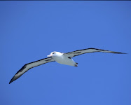
Alby is a Laysan Albatross. He was born and raised in the Midway Islands, not far from the very same Laysan Island that gives names to all the individuals of his species. His parents fed him for six months. They alternated trips of one or two weeks, during which one of them was feeding and the other was protecting Alby and the nest. The long intervals were necessary because often the food was very far away, up to 400 or 600 miles away. They fed him until he became as big as them, and then suddenly deserted him. They did that because they instinctively knew that he was developed enough to take care of himself from then on. And they could not spend all their energies in raising a chick. Although they can live 40 to 60 years, they can only raise a chick every couple of years.

The young albatross did not know all the tricks of life at sea, and the first year he had difficulties at times. One half of the fledglings do not make it through the first season, but Alby did, and everything was much easier after that. He went out on the open ocean and did not come back for years, not touching land at all, living off the bounty of the ocean, sleeping on it, learning to travel using the wind forcing the air up against the moving ridges formed by the waves.

Alby came back to his native island when he was three years old, because his biological clock was giving him the urge to look for a mate. His tentative dances with prospective mates were as clumsy as those of the other young albatrosses around him. Naturally nothing happened, but he experienced and practiced the ways of the elders.

He is 4 years old now. He has wandered the ocean all this time. He has gone through the vast expanses of water finding food, freedom, and safety. He has gone to the north Pacific and flown around the Aleutian Islands and the Gulf of Alaska and the fiords of British Columbia. Next year he will try again to go back to his birthplace to search for a mate, and probably will find one.

Albatrosses are at home in the open ocean, keeping at least 30 miles offshore. But Alby is different. He is curious about the land, just as curious as a young soul can be. In his voyages near the northern seashores he watched eagles fishing for salmons. That was not his preferred food, but he looked with interest at this different method of fishing. He communicated with the eagles, answering their whistles with his screeches.

He is fascinated by the land, but unable to penetrate it - he is used to mastering the wind over the waves, and the different way of flying inland is unfamiliar to him. He asked Eagle about the extent of the land, and Eagle said that there is land up to the summit of those far away mountains to the east, and more.

One day he met Pelican, and while they were floating and chatting over the gentle waves of a mild afternoon he learned that Pelican had actually been inland while flying with his flock. He had flown across the fertile valley of California, and over the magnificent mountains of the Sierra Nevada and farther more to the northeast. Alby learned that inside the land, beyond those far away mountains, there is a great lake, and peaks with snow, and forests and valleys, and towns and people.

Pelican described the beauty of the land, which is called America, according to what he heard when people talked about it. Being a sociable character, when he was inside the land Pelican also had contacted other big birds and knew a good deal about what lay farther inside that large country.

Pelican learned from the other birds that there are large deserts and arid mountains in the interior highlands. There are very few people in those deserts, few roads, few machines. Nature is mostly untouched by man there, with many animals running free. The air is not disturbed by artificial smells and mechanical noises. It takes many days of overflying this natural environment before reaching the majestic mountains of the Continental Divide. Here the land is green again with large forests. Snow may remain up to late summer, the rocks are harsh and austere.

From there one can overfly the vast farmlands that gradually decrease in elevation until they make room for the mighty rivers that cut the America land in two. Pelican had also contacted seagulls that told him about more land to cross going east, with plenty of houses and towns and people. There are cities sporting very high buildings that tower up toward the sky. There are rivers and lakes where an aquatic bird can feed. He heard tales from vultures and hawks that there is another long range of lower mountains and beyond that, couple of days away as the crow flies, there is ocean again.

Alby would like to go inland, see the beauty of the country, but he is not fit to go there. He does not know how to master the thermals the way eagles, pelicans and other birds with big wings travel there. He is made for the ocean.

Still he would like to go and try to cross this enormous island that he cannot cross, and get to the sea on the other side.

One day he flies along the shore, and sees some very big wings flying along the cliffs of the big town called San Francisco, as he understands people call this place.

Approaching those big wings, he realizes that there are people hanging on them. He discovers then that people cannot fly on their own, but have created artificial wings that support them. He knows what they are doing; he knows how to fly along the cliffs. He knows that, ‘cause such was the very kind of flight he took when he left his nest for the first time.
Soon those cliffs become a favorite place for Alby. He flies there often and so close to the flying people that learns many of the words they speak. He listens and learns that there are even bigger and faster flying machines with long wings for the people that like to fly like birds, which are called gliders or sailplanes. And there are flying crafts with propelling engines, capable of transporting many people at high speed. He understands now what are those enormously high flying machines that cross the ocean, so high that he barely can hear their sound through the whistle of the wind.

The flying people are impressed by the unusual behavior of this albatross, which so often flies with them instead of flying far away in the ocean like others members of the same species. They imagine that Alby wants to travel ashore, but does not trust doing it by himself.

The soaring people offer to take Alby inland, and to show him the beauty of the countryside. They offer to take him aboard their flying machines and let him cross this big island in silent winged crafts, no noises, no vibrations, no offending gas smells.

Alby accepts the invitation. He wants to see the mountains, the valleys, the lakes, the deserts and the forests, and the towns and the towers, and the roads and the bridges and the rivers of this beautiful land called America. He realizes that it is not possible for him to travel here alone, without the help of the flying people.

So the soaring people take Alby in their silent aircrafts across that vast territory. They understand. Because they themselves share the curiosity, the need for adventure, the thirst for knowledge of that young spirit. They share the independence that flying gives, the endless autonomous decisions that need to be taken in this constantly moving environment. They know the far-reaching view that this privileged position allows. But most of all, they share the elation of infinite freedom by being immersed in the sky, floating, suspended in the brilliance of this transparent ocean. Those are the reasons why they aimed for the skies, and now they cannot live any more without the magic of flight.

They take Alby with them, in the togetherness that unites all aviators. Alby’s great voyage has just begun.

Rules

ORGANIZATION OF THE VOYAGE

This website is recording the flights of Alby, his whereabouts and his flight log. The webmaster of the site is the Albymaster. All news and inquiries about Alby will be handled by this site.

Alby wishes to soar across America. He wishes to see it all, across to the Atlantic Ocean, and then back to the West Coast where his voyage began.

Alby flies only in aircraft that use the energy contained in the atmosphere as a means for traveling. Motorgliders can use their engine only for taking off.

A proposal to fly with Alby shall be sent to the Albymaster. A proposal shall include a pre-declaration of the proposed flight.

Preference will be given, in order, to the site that is closer to Alby’s current location, to the first proponent in order of time, to soaring clubs or associations, to groups of pilots, or to an individual pilot. This means, for example, that an individual pilot has to wait for the soaring club to fail its attempt, before making its own attempt.

A club or pilot that has proposed to fly with Alby and has been accepted by the Albymaster, will be called the Albypilot. When a proposal is accepted, the flight should be made before the end of the next Friday.

If no other Albypilots have made the flight on their assigned week, the hosting club or pilot will have the right to make the flight before the end of the next Friday. If the host did not propose or is not able to make the flight, the next Albypilot shall make the flight before the end of the next Friday. And so on.

RULES FOR THE FLIGHT

Gliders can be towed to an altitude not exceeding 3,000’above take-off. Motorgliders will shut off their engine before that altitude is reached. The release or engine shut-off point shall be west (east when coming back) of the take off field.

Each landing point will be to the east of the take-off point, and when coming back, to the west. If difficulties arise, an occasional back leg may happen, when accepted by the Albymaster.

The flight should end in a soaring site, or a place from where a glider can be towed out. If the flight does not end in the pre-declared location, the Albypilot or a pilot of the same club still have to the end of the next Friday to try and complete the flight as declared. If the pre-declared location still is not reached, Alby must be taken back where it started (not necessarily by flying).

Both the current host of Alby and the new host shall communicate the outcome of the flight to the Albymaster.

If the flight cannot be made before the end of the next Friday by the first Albypilot, it is the responsibility of the first Albypilot to give notice of the inability to make the flight, with timely courtesy, to the Albymaster, to the host, and to the second proponent in line.

The Albypilot who flies with Alby is responsible for keeping good care of him. When the Albypilot represents a soaring club or association, the representative of the club or association will be responsible for the well being of Alby.

The above rules may be superseded by the Albymaster when atypical circumstances arise.

Order of Preferences:

1 - The club that is closer to Alby’s current location
2 - The club that proposes first in order of time
3 - Clubs, soaring associations, soaring centers
4 - Group of pilots
5 - Individual pilots

ACCESSORY RULES

When start altitude, release to the west, landing to the east are difficult because of special local conditions, an exception may be requested to the Albymaster.

When an Albypilot cann0t make the flight in the week he/she has been assigned, another Albypilot can make the flight provided he/she has been accepted by the Albymaster.

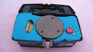
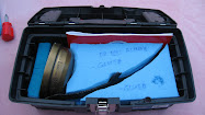
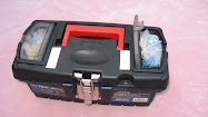
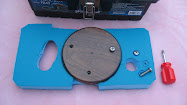
LOGBOOK, LAPEL PINS, SPOT DEVICE, GPS TRACE

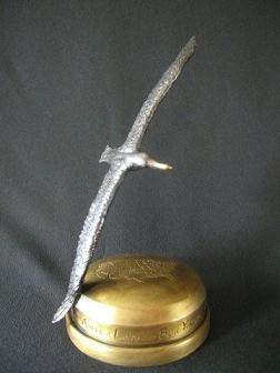
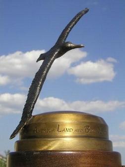
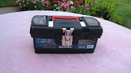
LOGBOOK - Alby travels with a logbook. The Albypilot will fill out the log entry and sign it. The flight data will be e-mailed to the Albymaster and an entry will be placed in the website logbook. A description of the flight and pictures may also be sent along with the flight data, to be posted in the website. Enter all flights, successfull or not.

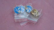
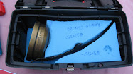
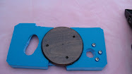
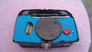
LAPEL PINS - The Alby case contains lapel pins. The pilot(s) successfully accomplishing a flight will get one pin each. The lapel pins are numbered. Check in the log book for the last pin number and take the subsequently numbered pin(s). If the flight is not successfull, place a bar in the last column (Pin No.). Please guard carefully the pins, we do not want them to misteriously disappear.

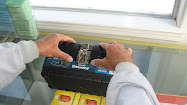
SPOT DEVICE - The SPOT device is to be placed in the glider in a place where there is sufficient visual contact with the outside (inside a shirt pocket is OK). It is to be used during the flight and placed in Alby's case when not flying. Instructions for use are in the case.

GPS TRACE - Pilots are encouraged to send their GPS log no matter how successfull the flight, as it will be posted in the map (flying with Alby is already a great success, to be recorded and displayed). Alternatively, it can be downloaded to OLC.
DISCLAIMER

Pilots who participate in Alby’s voyage acknowledge that it is a voluntary effort, and that the timing, route selection, weather decisions, and all other aspects of the flight are the sole responsibility of the pilot in command of the aircraft in which Alby is transported. The Organizers of Alby’s voyage, retain all rights to the concept, images, logbook, Alby trophy, and eventual chronicle of the journey, but neither they nor volunteers involved in the project nor the Pacific Soaring Council (PASCO) nor the Soaring Society of America (SSA) are in any way responsible for the decisions of the pilots that carry Alby in their aircraft. When pilots propose to carry Alby on part of his journey, they warrant that they have sufficient experience and will exercise all due caution to ensure the safety of their flights. By allowing pilots to carry Alby, the Organizers of the Alby project are merely keeping track of and attempting to facilitate the continued progress of Alby’s voyage.

WAIVER AND ASSUMPTION OF LIABILITY

Please accept me as a participant in the Alby voyage. In consideration of acceptance of this entry, for myself, my heirs, executors, administrators, personal representatives, successors or assigns I hereby release and discharge the Organizers, The Pacific Soaring Council (PASCO) THE SOARING SOCIETY OF AMERICA, INC., and their agents, representatives, employees, successors or assigns from any and all claims for damages or injuries suffered by me or by any member of my crew during the aforementioned soaring venture.
I further agree to assume full responsibility for and to indemnify, defend and hold the aforementioned entities and persons harmless from any and all legal obligations for damages to personal property owned by, or injuries suffered by, any spectator or contestant or personnel of the aforementioned entities, or by any other person or entity, which may be caused directly or indirectly by my participation in the venture. I further certify that I have read, understand, and agree to abide by the rules and regulations of the aforementioned endeavor.
I fully understand and agree that I am waiving any claim for damages that I may suffer by virtue of any act of negligence arising in the future by any act or omission of any of the aforementioned entities or persons or their agents, representatives or employees, and that the consideration for this waiver is the permission by the sponsoring or presenting bodies of the aforementioned venture allowing me to participate in the said venture and that such permission is being granted me in the reliance upon this waiver as set forth in this entry form.


Logbook

Tracking the flights with SPOT

Tracking the flights with SPOT
Where in the world is Alby?

Follow Alby flying in real time on our Spot satellite tracking page.

Position updates are broadcast in real time every 10 minutes. If Alby is not flying at this time, the trace shows Alby's most recent flight. Traces are left posted for the duration of one week only. However, the flight can be seen on OLC.

ALBY'S VOYAGE is sponsored by StrePla USA, who donated the SPOT carried in the flight and the tracking service for it. No other compensation is received by ALBY'S VOYAGE from StrePla USA. SPOT enhances flying safety and this is the best reward for ALBY'S VOYAGE to promote its use. See details of the offer here below.

Anyone who orders a SPOT from StrePla USA and refers to the ALBY's VOYAGE, will receive a free nylon case ($39 value) and a coupon for free tracking ($49) for one year. The price is $149.95 plus S&H or $135 ea for orders of 10. This offer is exclusive to ALBY'S VOYAGE and StrePla USA. No need to be part of the Voyage in any way. Just mention ALBY'S VOYAGE when ordering. Click here for details of SPOT features.

To order your SPOT, contact:

StrePla USA
1501 East Stanford Avenue
Englewood, CO 80113
303-981-5717 cell
303-781-4515 home
303-762-8784 fax
discus2a@qwest.net